History in Structure

Churchyard cross in St Andrew's Churchyard

A Grade II Listed Building in Dinas Powys, Vale of Glamorgan

More Photos »
Approximate Location Map
Large Map »

Coordinates

Latitude: 51.4355 / 51°26'7"N

Longitude: -3.2405 / 3°14'25"W

OS Eastings: 313867

OS Northings: 171454

OS Grid: ST138714

Mapcode National: GBR HV.NX6L

Mapcode Global: VH6FK.S57W

Plus Code: 9C3RCQP5+6R

Entry Name: Churchyard cross in St Andrew's Churchyard

Listing Date: 3 May 2002

Last Amended: 3 May 2002

Grade: II

Source: Cadw

Source ID: 26501

Building Class: Religious, Ritual and Funerary

ID on this website: 300026501

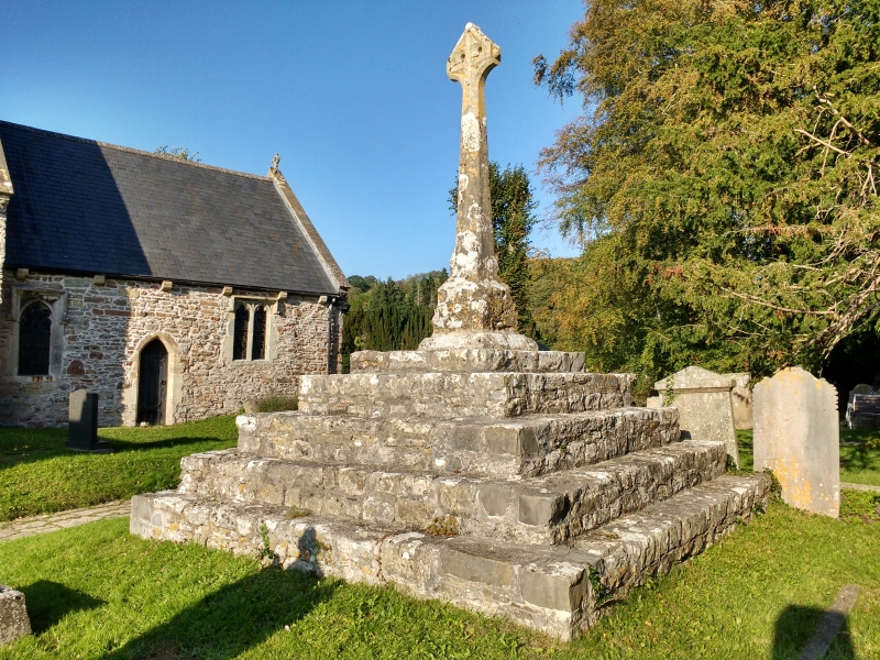
Location: Standing S of the church.

County: Vale of Glamorgan

Community: Dinas Powys

Community: Dinas Powys

Locality: St Andrews Major

Traditional County: Glamorgan

Tagged with: Christian cross

Find accommodation in
Dinas Powis

History

Medieval, restored in C19.

Exterior

Churchyard cross. A high base of 5 square steps of mortared rubble. Original square socket on a plinth; the shaft with broach spurs was displaced but recovered; cross head was restored.

Reasons for Listing

Listed as a large and mostly surviving medieval cross with its steps; group value with the church, the bier house and The Old Rectory.

External Links

External links are from the relevant listing authority and, where applicable, Wikidata. Wikidata IDs may be related buildings as well as this specific building. If you want to add or update a link, you will need to do so by editing the Wikidata entry.

Recommended Books

Other nearby listed buildings

  • II* Church of St Andrew
    On low-lying ground in the centre of the hamlet, a still rural community NW of the urban development of Dinas Powys, standing in a roughly rectangular churchyard with retaining wall incorporating ston
  • II The Bier House in St Andrew's Churchyard
    In the SW corner of the churchyard facing E.
  • II* The Old Rectory
    Situated on SW side of the church, within the grounds of The Rectory and reached by a drive through that property.
  • II Garn-hill and attached garden terrace
    On a south facing slope NE of the hamlet of St Andrews Major, reached by a long drive from the hamlet and set in terraced gardens.
  • II Lon Twyn
    On rising ground NW of the village centre, set within terraced gardens with views S over the Bristol Channel.
  • II The Mount
    Facing the Common on ground rising from and SW of the village centre. Set back from the road in a walled garden with entrance comprising tall rendered piers and tall decorative wrought iron gates.
  • II Dinas Powys Parish Hall
    Just to W and on rising ground above the village centre, on a railed and walled terrace of random stone reached by steps.
  • II Remains of Dinas Powis Castle
    On a wooded spur in Castle Wood, immediately above the C20 development of Lettons Way and reached by footpath from there.

BritishListedBuildings.co.uk is an independent online resource and is not associated with any government department. All government data published here is used under licence. Please do not contact BritishListedBuildings.co.uk for any queries related to any individual listed building, planning permission related to listed buildings or the listing process itself.

British Listed Buildings is a Good Stuff website.