Approximate Location Map
Large Map »
Latitude: 52.9178 / 52°55'4"N
Longitude: -4.096 / 4°5'45"W
OS Eastings: 259167
OS Northings: 337654
OS Grid: SH591376
Mapcode National: GBR 5R.N7GF
Mapcode Global: WH55M.1XSJ
Plus Code: 9C4QWW93+4H
Entry Name: Castellated Garden Walls and Towers at Castell Deudraeth
Listing Date: 23 August 2002
Last Amended: 23 August 2002
Grade: II
Source: Cadw
Source ID: 26885
Building Class: Gardens, Parks and Urban Spaces
ID on this website: 300026885
Location: Enclosing lawns and terraces to the SW of Castell Deudraeth
County: Gwynedd
Community: Penrhyndeudraeth
Community: Penrhyndeudraeth
Locality: Portmeirion
Traditional County: Merionethshire
Tagged with: Wall
Castell Deudraeth is named after the now lost late C12 castle built on a commanding site near what is now Pormeirion village, to the SW. The original house, possibly of C18 origin, was enlarged in the early C19 to form a sizable mansion, at that time called Bron Eryri. In 1841 the house was bought by a lawyer/landowner named David Williams (1799-1869), who served as Meirionethshire's first Liberal MP. Williams enlarged and castellated the house in the 1840s and 50s, renaming it Castell Deudraeth. The castellated garden walls and playful turrets are part of this remodelling.
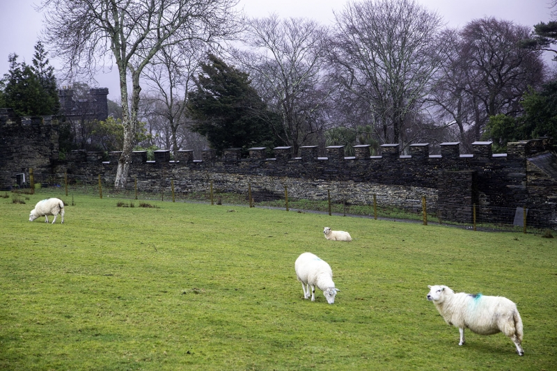
Sequence of castellated garden walls and towers; of rubble construction. The wall starts at the SW corner of Castell Deudraeth at a height of approximately 4m. It runs in a south-westerly direction for approximately 25m, closing the lawns to the rear of the house on the L side and acting as a high revettment with terrace above. At intervals of roughly 5m are three deep niches set within this stretch, each with depressed brick arch. At the end is a square tower of approximately 8m in height. This has a corner turret to the E and a plain opening with slate lintel to the NE; Gothick pointed-arched windows to the ground and upper floors on the SE (lawn-facing) side.
The wall continues beyond the tower for an equivalent distance, though with fewer crenellations and at a slightly reduced height; in front is a low terrace with 1m revettment, accessed via steps at the tower. The wall then turns a right-angle and steps up beyond an opening onto the low terrace, to continue north-westwards for approximately 15m. At the end of this stretch is a plain, wide opening, beyond which the wall terminates in a part-castellated square tower of approximately 4m in height. This tower is castellated only on the NE and SE (house-facing) sides, and conceals a simple single-storey lean-to store with modern boarded SW side. The wall turns another right-angle at this point and continues for some 22m in a north-easterly direction back towards the house and running parallel with the lower wall. It terminates finally in a tower, as before.
At the end of the lower terrace wall a further low wall adjoins and runs in a wide arc to follow the lane; this steps up and down at 1m and 2m heights variably and eventually terminates in a flight of steps with iron railings beyond towards the SE corner of the house. Approximately two-thirds along the length of this last stretch of wall is a tall, circular turret with open rear.
Listed as a sequence of early Victorian Gothic-style castellated garden walls and turrets forming an important part of the setting of Castell Deudraeth.
Group value with Castell Deudraeth
External links are from the relevant listing authority and, where applicable, Wikidata. Wikidata IDs may be related buildings as well as this specific building. If you want to add or update a link, you will need to do so by editing the Wikidata entry.


Other nearby listed buildings
