History in Structure

Stone needle 500m SW of Plas Penrhyn

A Grade II Listed Building in Penrhyndeudraeth, Gwynedd

More Photos »
Approximate Location Map
Large Map »

Coordinates

Latitude: 52.9187 / 52°55'7"N

Longitude: -4.1001 / 4°6'0"W

OS Eastings: 258897

OS Northings: 337763

OS Grid: SH588377

Mapcode National: GBR 5R.N0J8

Mapcode Global: WH55L.ZWQT

Plus Code: 9C4QWV9X+FX

Entry Name: Stone needle 500m SW of Plas Penrhyn

Listing Date: 23 August 2002

Last Amended: 23 August 2002

Grade: II

Source: Cadw

Source ID: 26883

Building Class: Gardens, Parks and Urban Spaces

ID on this website: 300026883

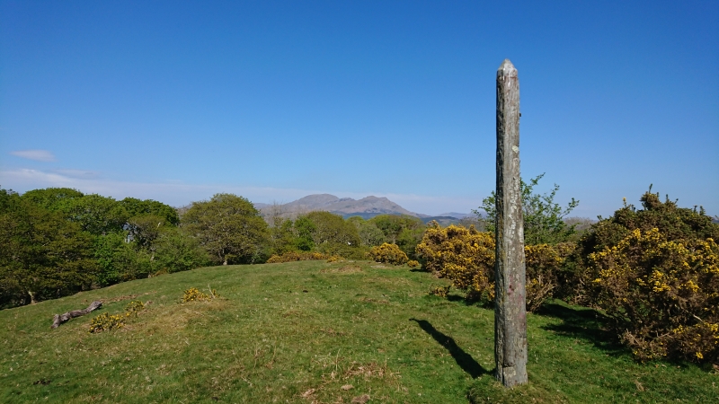
Location: In a field on an elevated site some 500m SW of Plas Penrhyn, with commanding views across the Traeth Mawr.

County: Gwynedd

Community: Penrhyndeudraeth

Community: Penrhyndeudraeth

Locality: Minffordd

Traditional County: Merionethshire

Tagged with: Architectural structure

Find accommodation in
Minffordd

History

Apparently built as an eyecatcher to serve Plas Penrhyn, probably at the time of the latter's remodelling for the industrialist Samuel Holland c1830.

Exterior

Narrow stone needle of obelisk type, approximately 3m in height; a single piece of slatestone.

Reasons for Listing

Listed as a second-quarter C19 eye-catcher.

External Links

External links are from the relevant listing authority and, where applicable, Wikidata. Wikidata IDs may be related buildings as well as this specific building. If you want to add or update a link, you will need to do so by editing the Wikidata entry.

Recommended Books

Other nearby listed buildings

  • II* Plas Penrhyn
    Located towards the western boundary of the community on a commanding, elevated site overlooking Porthmadog and theTraeth Mawr; accesed via a lane running SW from the main road (A 487).
  • II Castellated Garden Walls and Towers at Castell Deudraeth
    Enclosing lawns and terraces to the SW of Castell Deudraeth
  • II Castell Deudraeth
    Within its own grounds on the Portmeirion estate, approximately 2km NE of Portmeirion village; accessed via a metalled drive leading W from the main Portmeirion lane.
  • II Former Weigh House at Boston Lodge Railway Works
    The railway yard known as Boston Lodge is a large complex at the south-east end of The Cob, facing Porthmadoc across the Traeth Mawr. This building is to north east of the main Boston Lodge buildings,
  • II Locomotive Shed at Boston Lodge Railway Works
    The railway yard known as Boston Lodge is a large complex at the south-east end of The Cob, facing Porthmadoc across the Traeth Mawr. This building is to the north east of the main Boston Lodge buildi
  • II Former Iron Foundry and Smithy at Boston Lodge
    The railway yard known as Boston Lodge is a large complex at the south-east end of The Cob, facing Porthmadoc across the Traeth Mawr. This building is at the north end of the main range, stepped down
  • II Former Machine Shop at Boston Lodge
    The railway yard known as Boston Lodge is a large complex at south-east end of The Cob, facing Porthmadoc across the Traeth Mawr. This building is set back to left of the Erecting Shop and is the cent
  • II Former Erecting Shop at Boston Lodge
    The railway works known as Boston Lodge is a large complex at south-east end of The Cob, facing Porthmadoc across the Traeth Mawr. This range is in front of the siding at the entrance to the works, at

BritishListedBuildings.co.uk is an independent online resource and is not associated with any government department. All government data published here is used under licence. Please do not contact BritishListedBuildings.co.uk for any queries related to any individual listed building, planning permission related to listed buildings or the listing process itself.

British Listed Buildings is a Good Stuff website.