Latitude: 51.4004 / 51°24'1"N
Longitude: -3.1952 / 3°11'42"W
OS Eastings: 316954
OS Northings: 167496
OS Grid: ST169674
Mapcode National: GBR HX.R302
Mapcode Global: VH6FS.K2P8
Plus Code: 9C3RCR23+5W
Entry Name: Swanbridge House
Listing Date: 25 September 2002
Last Amended: 25 September 2002
Grade: II
Source: Cadw
Source ID: 26974
Building Class: Domestic
ID on this website: 300026974
Location: Directly facing the sea, separated from it only by a narrow lane; within a garden bounded at front by a wall with cast iron railings,gates and iron gatepiers.
County: Vale of Glamorgan
Community: Sully and Lavernock (Sili a Larnog)
Community: Sully
Locality: Swanbridge
Traditional County: Glamorgan
Tagged with: House
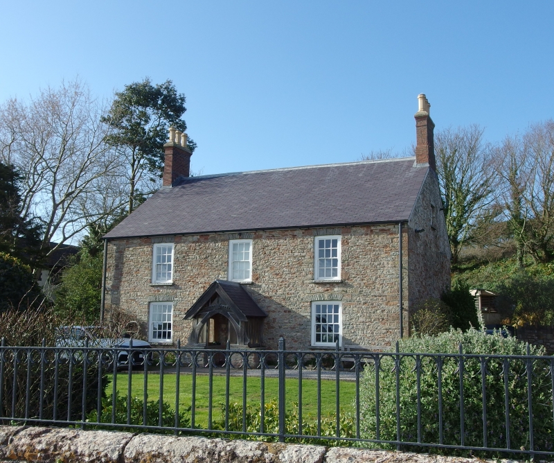
Probably early C19 in present form. Formerly a farmhouse on the Bute Estate. Adjacent to the site of now demolished Sully House, of the Sully estate, where Evan Thomas, the owner and agricultural improver lived in early C19: the division between the parishes of Sully and Lavernock, which includes Swanbridge, is between the two. Swanbridge had a slipway and there are records of shipping operating in the area from C16. Kelp was prepared by burning seaweed in pits - 1 ton of kelp from 20 tons of seaweed - and exported. Other exports were local plants, including sea-holly, sent to Bristol for medicines. Main exports in C17 and C18 were cheese, butter, wool, woollen goods and livestock. Coastal trade declined at end of C18 with closure of ferry between Sully and Uphill on the other side of the Bristol Channel. On the slopes to rear (now off the Lavernock Road) The Bute Estate later and until 1920 experimented in viticulture and established a 5 acre (2 hectare) vineyard, the grapes processed in Cardiff Castle Gardens. The map of 1845 shows the house with a long cross range front left and a further 2 buildings and wall to right; First edition OS map shows further ranges to left. Well to rear. The porch was re-erected here from an old house elsewhere.
Double-fronted detached Georgian house. Of mainly unrendered rubble with dressed stone dressings; slate roof with tall and narrow brick corniced stacks. Windows are sashes under slightly cambered voussoirs within painted reveals; 3 12-pane to top floor and two 16-pane either side of gabled porch which has a stone plinth, wooden braces forming an arched entrance, deep bargeboards and boarded door; plain fanlight.
Interior retains shutters, 6 panelled doors, basket arches. Fireplaces replaced.
Listed as a Georgian house retaining its character in an outstanding seaside position.
External links are from the relevant listing authority and, where applicable, Wikidata. Wikidata IDs may be related buildings as well as this specific building. If you want to add or update a link, you will need to do so by editing the Wikidata entry.


Other nearby listed buildings