History in Structure

Telephone Call-box to N of Miner's Arms PH

A Grade II Listed Building in Llanferres, Denbighshire

More Photos »
Approximate Location Map
Large Map »

Coordinates

Latitude: 53.1401 / 53°8'24"N

Longitude: -3.1944 / 3°11'39"W

OS Eastings: 320198

OS Northings: 360992

OS Grid: SJ201609

Mapcode National: GBR 6X.64KJ

Mapcode Global: WH77B.XB0L

Plus Code: 9C5R4RR4+26

Entry Name: Telephone Call-box to N of Miner's Arms PH

Listing Date: 6 December 2002

Last Amended: 6 December 2002

Grade: II

Source: Cadw

Source ID: 80713

ID on this website: 300080713

Location: On small green area to N of Miner's Arms PH

County: Denbighshire

Community: Llanferres

Community: Llanferres

Locality: Maeshafn

Traditional County: Denbighshire

Tagged with: Red telephone box

Find accommodation in
Llanferres

History

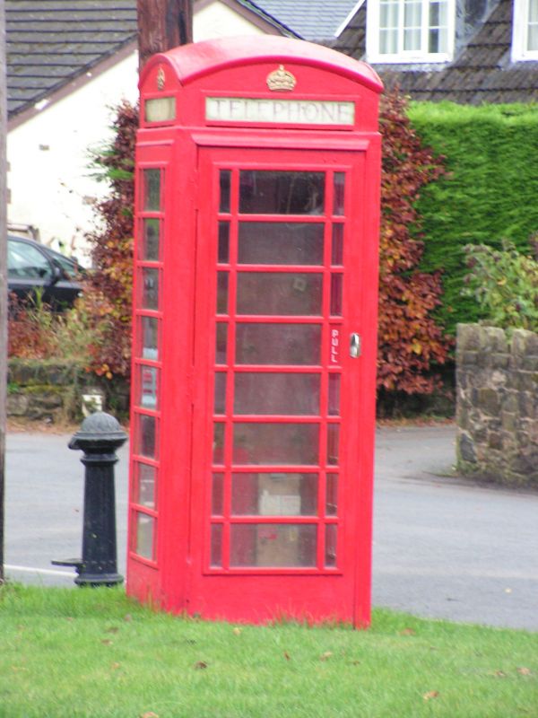
Datable to reign of George VI.

Exterior

K6 type box to the standard design of Giles Gilbert Scott. The design was introduced by the General Post Office in 1936. This example dates from the reign of George VI, and was manufactured by the Carron Company. Domical roof with lunettes enclosing embossed Imperial Crowns over red-lettered opals and ventilation slits. Raised surrounds to sides and door with marginal bars to horizontal glazing; moulded plinth.

Reasons for Listing

Listed for its contribution to village centre of this settlement in the Clwydian Hills Area of Outstanding Natural Beauty.

External Links

External links are from the relevant listing authority and, where applicable, Wikidata. Wikidata IDs may be related buildings as well as this specific building. If you want to add or update a link, you will need to do so by editing the Wikidata entry.

Recommended Books

Other nearby listed buildings

  • II Nant Cottage
    Reached along a by-road E off A494 towards Maeshafn; NE of Llanferres. Set back from the road, below the hill on a levelled site.
  • II Holt Hostel
    On the slopes of Moel Findeg, c750m SE of the village of Maeshafn, in woodland on the NE side of the lane
  • II Pont-y-Mwynwr
    Situated 0.9 km W of Maeshafn close to a bridge over the River Alyn, set back off the road. Reached along a by road E off A494 towards Maeshafn; NE of Llanferres.
  • II Ty'n y Fedw
    In the grounds of Colomendy Hall, on the edge of woodland approx 0.5km SSW of the hall, and S of Glan Alyn. The house is set in a stone-walled enclosure, bounded by the remains of its farm-buildings
  • II Aberduna Engine House
    Situated in the edge of woodland NE of Aberduna Quarry. Reached by a footpath running W from the by road between Maeshafn and Gwernymynydd.
  • II Bridge at Cascade Wood
    Set in the heart of Cascade Wood south east of Tafarn-y-Gelyn and west of Maeshafn. Spanning the River Alyn and reached from a woodland footpath off a lane to the east of the river.
  • II Glan-y-Afon
    Situated 0.5 km E of Tafarn-y-gelyn in its own grounds beside the River Alyn. Reached from a drive running E off the A494 between Tafarn-y-Gelyn and Loggerheads.
  • II Colomendy Hall
    Situated 0.3 km SE of the Loggerheads Inn PH, reached from a drive which runs S off the A494 beside the Three Loggerheads PH.

BritishListedBuildings.co.uk is an independent online resource and is not associated with any government department. All government data published here is used under licence. Please do not contact BritishListedBuildings.co.uk for any queries related to any individual listed building, planning permission related to listed buildings or the listing process itself.

British Listed Buildings is a Good Stuff website.