Approximate Location Map
Large Map »
Latitude: 51.671 / 51°40'15"N
Longitude: -3.3304 / 3°19'49"W
OS Eastings: 308092
OS Northings: 197757
OS Grid: ST080977
Mapcode National: GBR HQ.5YTD
Mapcode Global: VH6DC.7859
Plus Code: 9C3RMMC9+CR
Entry Name: Pontygwaith Overbridge
Listing Date: 20 February 2003
Last Amended: 5 April 2016
Grade: II
Source: Cadw
Source ID: 80908
ID on this website: 300080908
Location: Reached down a steep by-road from the old Cardiff to Merthyr road; by-road crosses the former Taff Vale Railway just before the overbridge.
County: Merthyr Tydfil
Town: Merthyr Tydfil
Community: Treharris
Community: Treharris
Locality: Pontygwaith
Traditional County: Glamorgan
Tagged with: Road bridge
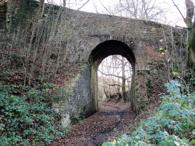
Overbridge carrying the track to Pont y Gwaith over the Penydarren tramroad, said to be mid C19 as crossing a diversion on the tramroad. The bridge immediately adjoins the bridge over the Taff Vale railway opened in 1841 and may have been rebuilt to accommodate the altered roadway. Restored as part of the Trevithick 2004 Project.
Road bridge over former tramroad, abutting railway bridge. Rubble stone, tall narrow arch with stone voussoirs and rubble stone, the parapets sloping up with roadway to abut railway bridge parapets.
Included for its special interest as a stone overbridge over the Penydarren tramroad, a nationally important feature in the history of iron production and railway development in Wales. Group value with the adjacent railway bridge.
External links are from the relevant listing authority and, where applicable, Wikidata. Wikidata IDs may be related buildings as well as this specific building. If you want to add or update a link, you will need to do so by editing the Wikidata entry.


Other nearby listed buildings
