Approximate Location Map
Large Map »
Latitude: 51.6704 / 51°40'13"N
Longitude: -3.3621 / 3°21'43"W
OS Eastings: 305904
OS Northings: 197730
OS Grid: ST059977
Mapcode National: GBR HP.5WKW
Mapcode Global: VH6DB.N8ZS
Plus Code: 9C3RMJCQ+55
Entry Name: Penrhiwceiber Institute and Community Hall
Listing Date: 10 March 2003
Last Amended: 10 March 2003
Grade: II
Source: Cadw
Source ID: 80942
ID on this website: 300080942
Location: Situated on the main thoroughfare near the railway station, on a corner site; on sloping ground with depths increasing to rear.
County: Rhondda Cynon Taff
Town: Mountain Ash
Community: Penrhiwceiber (Penrhiw-ceibr)
Community: Penrhiwceiber
Built-Up Area: Mountain Ash
Traditional County: Glamorgan
Tagged with: Architectural structure
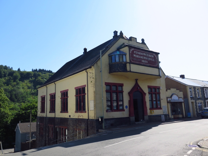
Built 1888. Was the Penrhiwceiber Miners'' Institute to 1993 when it was refurbished. Prior to World War II it was owned by Penrhiwceiber Colliery (pit sunk 1873 - owners Messrs Cory,Glasbrook and Yeo) and dedication stone laid by Richard Cory. It was later bought for the miners through John Peregrine. It is unusual in being owned by the miners rather than the colliery. Because of difficulties with the Welsh name, the pit came to be known as Penrikyber: it had three shafts and employed about 1000 men. There was close association with the nearby Welfare Institute (listed) which provided further facilities. The lower floor meeting room retains a series of photographs of the management committees from early times. The box for cinema projection was added some 20 years after construction in the early 1900s and is mainly unaltered. The refurbishment in 1993 retained most of the historic fabric and added an office to the side in place of a shed. An early photograph taken after the installation of the projection booth shows it with windows over the central doorway; also a parapet to the frontage at eaves level, arched surrounds to the windows, chimneys and a pitched not hipped roof to the booth.
Entertainment hall with a modest Gothic Revival style frontage. Fronted with scored render on a plinth of rockfaced stone; window and door surrounds are of ashlar; at side the main storey is of painted brick with basement of rockfaced stone; Welsh slate part-hipped roof with moulded eaves and ventilators. Main street frontage is dominated by the hipped roofed projection box cantilevered out at first floor level with side bay windows with lead roofs. Above, the gable is cut off to form a parapet with end finials and central stepped datestone. Ground floor has central round-arched doorway within gabled and buttressed surround, incorporating dedication stone at base and apex finial above; panelled double doors. On either side are tri-partite cross-framed windows with segmental-arched heads. To side is a range of four tri-partite cross-framed windows with square heads to hall floor; smaller mullioned basement windows with segmental-arched brick heads. Glazing within the stone frames has been renewed.
Interior is an open hall with raked seats to rear and proscenium arch and stage to front. Ceiling is boarded and painted incorporating recesses for ventilators. The proscenium arch, with fluted end pilasters, is a 3-centred arch, rising from a cornice with a scrolled pediment motif at apex. The panelled wings to side have pedimented doorways. Tip-up seats to the raked rear. Swing doors. Lower floor meeting rooms.
Listed as a historically interesting local entertainment hall built for miners and their families and still in community use, which retains most of its original fabric and an interesting early projection booth.
External links are from the relevant listing authority and, where applicable, Wikidata. Wikidata IDs may be related buildings as well as this specific building. If you want to add or update a link, you will need to do so by editing the Wikidata entry.


Other nearby listed buildings
