Approximate Location Map
Large Map »
Latitude: 52.9004 / 52°54'1"N
Longitude: -3.2073 / 3°12'26"W
OS Eastings: 318888
OS Northings: 334342
OS Grid: SJ188343
Mapcode National: GBR 6X.P7DS
Mapcode Global: WH78H.PCXB
Plus Code: 9C4RWQ2V+53
Entry Name: Hendre
Listing Date: 4 January 1966
Last Amended: 4 November 2003
Grade: II
Source: Cadw
Source ID: 648
Building Class: Domestic
ID on this website: 300000648
Location: Located at the end of a short track which runs NE from Pont Ricket.
County: Wrexham
Community: Ceiriog Ucha
Community: Ceiriog Ucha
Locality: Pont Ricket
Traditional County: Denbighshire
Tagged with: Architectural structure
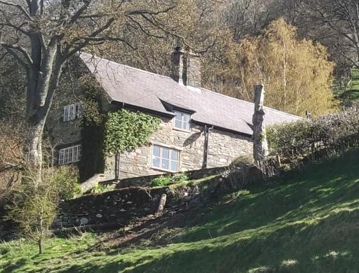
The down-hill siting of the farm-house suggests its early origins. Internal timberwork indicates a late sixteenth or early seventeenth century date, and delineates a lofted, 3-unit stone-built house. At some time, perhaps in the late eighteenth century, the house was raised in height (the earlier roofline is visible in the lower gable end) to provide a full upper storey. In 1990, it was sympathetically extended with a rear outshut; minor re-ordering of internal arrangement (particularly to first floor) took place at the same time.
Aligned against the slope, Hendre is a one and a half storeyed, 3-unit house of local granite rubble with rough plinth in rear wall and roughly dressed quoins; Ffestiniog slate roof with tall stone axial stack. Main elevation faces south, with doorway in gabled porch at right of central unit. Modern timber casement windows of 2 and 3 lights to ground floor, with similar windows above, those to centre and left in swept dormers(?). Some disturbance in the wall between the two left hand windows of the ground floor suggests alteration in this bay (where a continuous timber lintel was discovered during restoration work in 1990). Lower gable end retains earlier (probably C18) small-paned cast iron casements of 4 and 5 lights in pegged frames. Small (partially blocked) entrance to cellar below. Doorway to loft (now a window) in upper gable. Rear outshut added in 1990 using local granite and Ffestiniog slate.
The house has a 3 unit plan, comprising two heated rooms either side of the axial stack, and an unheated room at the upper end. Entrance into the central room, against the substantial remains of a post-and panel partition dividing this room (presumably originally the hall) from a service room. Hall has chamfered longitudinal beam and stop-chamfered joists. Rough chamfer to bressumer of large fireplace. At the lower end of the house, the second heated room has similar detail, both to fireplace and ceiling, which has two lateral beams with harts-tongue stops. By contrast, the present kitchen (the former buttery) has a roughly worked beam. Layout at first floor altered, but exposed truss at upper end (above the partition) is of relatively late type; purlins of lower bay are roughly worked chestnut, contrasting with the adze-dressed oak in the upper and central bays.
Listed as a sub-medieval house retaining traditional form and character, sympathetically restored. The centre of a good farmstead group.
External links are from the relevant listing authority and, where applicable, Wikidata. Wikidata IDs may be related buildings as well as this specific building. If you want to add or update a link, you will need to do so by editing the Wikidata entry.


Other nearby listed buildings
