History in Structure

Pont yr Hendwr

A Grade II Listed Building in Llandrillo, Denbighshire

More Photos »
Approximate Location Map
Large Map »

Coordinates

Latitude: 52.9356 / 52°56'8"N

Longitude: -3.4259 / 3°25'33"W

OS Eastings: 304262

OS Northings: 338531

OS Grid: SJ042385

Mapcode National: GBR 6M.M29B

Mapcode Global: WH786.BGVV

Plus Code: 9C4RWHPF+6J

Entry Name: Pont yr Hendwr

Listing Date: 3 October 2003

Last Amended: 3 October 2003

Grade: II

Source: Cadw

Source ID: 81891

Building Class: Transport

ID on this website: 300081891

Location: Carrying the B4401 over the Afon Lynor, approx 1.7km N of Llandrillo. The Llynor is a tributary of the River Dee.

County: Denbighshire

Community: Llandrillo

Community: Llandrillo

Locality: Hendwr

Traditional County: Merionethshire

Tagged with: Bridge Road bridge
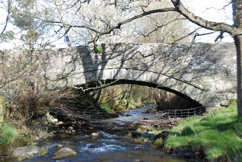
Find accommodation in
Cynwyd

History

Probably C18.

Exterior

Small single-span bridge with humped deck constructed of rubble stone. Low segmental pointed arch of narrow stone voussoirs with dripstone. Continuous parapets with flat stone copings. Abutments continue as rubble stone walls, following road to N, curving round to lane to SE, and with butt joint to SW, from where it continues to a driveway.

Reasons for Listing

Listed as a small unaltered C18 road bridge retaining its character. Group value with Hendwr Barn.

External Links

External links are from the relevant listing authority and, where applicable, Wikidata. Wikidata IDs may be related buildings as well as this specific building. If you want to add or update a link, you will need to do so by editing the Wikidata entry.

Recommended Books

Other nearby listed buildings

  • II Hendwr Barn
    Located on the W side of the road approx 1.7km N of the village, and immediately SW of Pont yr Hendwr. The gable end faces the road.
  • II* Plas-yn-Faerdref
    Located off the E side of the road, in a slightly raised position, approx 2km N of Llandrillo.
  • II Melin y Glyn
    Located off a lane which runs E from the B4401 at Pont yr Hendwr following the Afon Llynor. The complex is set down from the N side of the lane. The mill bounds the E side of a yard, which contains
  • II Pen y bryn
    Located off a lane which runs E from the B4401 at Pont yr Hendwr, following and then crossing the Afon Llynor. Set back from the N side of the lane in a slightly raised position surrounded by gardens
  • II Hendwr
    Located off the W side of the road and approx 2.3km N of the village. Reached down a long tree-lined avenue which leads from Pont yr Hendwr. The front faces E, with gardens to sides and rear.
  • II Rhyd y Glafes
    Located off the B4401 road, approximately 1.5km S of Cynwyd village.
  • II War Memorial
    Located on grass in front of the Community Hall.
  • II Pont Lladrillo
    Carrying the High Street over the Afon Ceidiog on the E side of the village.

BritishListedBuildings.co.uk is an independent online resource and is not associated with any government department. All government data published here is used under licence. Please do not contact BritishListedBuildings.co.uk for any queries related to any individual listed building, planning permission related to listed buildings or the listing process itself.

British Listed Buildings is a Good Stuff website.