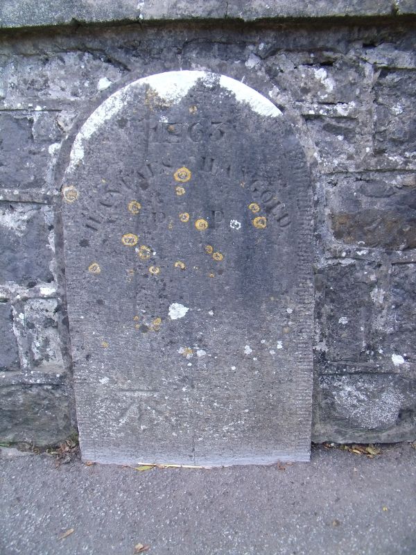
Boundary stone on Pont y Brenhin (partly in Llangoed)
A Grade II Listed Building in Llangoed, Isle of Anglesey
Coordinates
Latitude: 53.2894 / 53°17'21"N
Longitude: -4.0884 / 4°5'18"W
OS Eastings: 260888
OS Northings: 378968
OS Grid: SH608789
Mapcode National: GBR JN80.9Z4
Mapcode Global: WH53W.5LD4
Plus Code: 9C5Q7WQ6+PJ
Entry Name: Boundary stone on Pont y Brenhin (partly in Llangoed)
Listing Date: 13 July 2005
Grade: II
Source: Cadw
Source ID: 84759
ID on this website: 300084759
Location: At the S end of Llangoed and built into the parapet of the bridge.
County: Isle of Anglesey
Community: Llangoed
Community: Llangoed
Built-Up Area: Llangoed
Traditional County: Anglesey
Tagged with:
Boundary marker
History
Dated 1863 and shown on the 1889 Ordnance Survey.
Exterior
A freestone marker with rounded top, inscribed '1863' and, on the L side, 'Llanfaes P', and on the R side 'Llangoed P'. Below is an OS datum.
Reasons for Listing
Listed for its special historical interest as one of a series of C19 stones of definite character that mark the boundary of Llanfaes parish.
External Links
External links are from the relevant listing authority and, where applicable, Wikidata.
Wikidata IDs may be related buildings as well as this specific building. If you want to add or update a link, you
will need to do so by editing the Wikidata entry.
Recommended Books
Other nearby listed buildings
-
II*
Tros-y-gors
Situated to E of B 5109 through Llangoed; reached from N end of the village along lane and then short private track. Faces N; rubble forecourt wall.
-
II
Outbuilding range at Haulfre Stables
Situated to E of B 5109 through Llangoed; reached from N end of the village along a lane and then short private track. The outbuilding range is set downslope to S of the adjacent stable complex.
-
II*
Castell Aberlleiniog
In an isolated location, along a trackway, to the N and W of a country road leading to Penmon; to the W of the village of Llangoed. The structure is to the N side of the Afon Lleiniog c0.5km from the
-
II
Haulfre Stables
Situated to E of B 5109 through Llangoed; reached from N end of the village along a lane and then short private track.
-
II
Trecastell Farm
Set back, along a private trackway, from the E side of the B5109 on its S approach to the village of Llangoed.
-
II
Plas Cichle
Reached by private drive on the W side of a minor road approximately 0.7km NNW of Llanfaes church.
-
II
Outbuilding on the W side of Plas Cichle
Immediately behind the house.
-
II
Cichle Farmhouse
Reached by private drive on the W side of a minor road approximately 0.6km NNW of Llanfaes church.