Latitude: 52.1248 / 52°7'29"N
Longitude: -3.3382 / 3°20'17"W
OS Eastings: 308486
OS Northings: 248237
OS Grid: SO084482
Mapcode National: GBR YR.88M4
Mapcode Global: VH6B1.3V3G
Plus Code: 9C4R4MF6+WP
Entry Name: Pen-castell
Listing Date: 24 September 2004
Last Amended: 5 August 2005
Grade: II
Source: Cadw
Source ID: 84995
Building Class: Domestic
ID on this website: 300084995
Location: 1km approx NE of Aberedw, approached via a track off the lane that runs NE from the village skirting the eastern flank of Aberedw hill. The house is situated towards the brow of the slope.
County: Powys
Community: Aberedw
Community: Aberedw
Traditional County: Radnorshire
Tagged with: Farmhouse
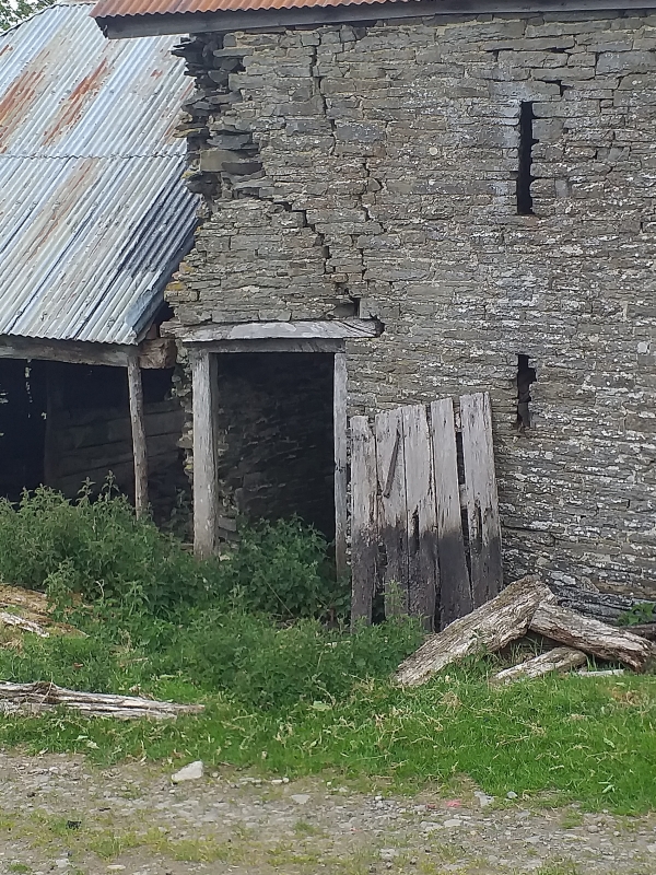
The farmstead is thought to be of medieval origin, and its down-hill siting, with the upper end set into a bank, is typical of medieval building. The present building has architectural detail of the early C19 but retains substantial elements from much earlier phases of construction. These have been posited as a cruck-framed, timber-walled hall house of c1550, with a chimney inserted c1600, and the external walls rebuilt in stone during the C17, at which time it appears to have been of long-house type, with direct access from house to the cow-house attached at the lower end. The early C19 remodelling of the house was extensive, involving the reconstruction of the front wall and the raising of the rear, and the complete re-ordering of the interior. The overall arrangement was changed to comprise a lobby entry house, with separate access to the cow-house. All this change was achieved within the original footprint of the building. Last occupied c1950, and in poor structural condition when inspected, April 2005.
Small farmhouse with remains of attached cow-house at lower end. Single storey and attic, a small 2-unit plan. Local quarried stone, roughly coursed. Slate roof with single stack at lower gable. Lobby entry plan with doorway against the stack, and two windows beyond, both 2-light casement windows with iron-glazing bars. Framed dormer within the roof. Attached at the lower end of the house is the former cow-house, now roofless, but with a single doorway alongside the entrance to the house. In here, the gable end of the house reveals significant evidence of its early history, including the blocked doorway of the C17 long-house which gave direct entry from house to cow-house, and the scarring of a former cruck truss: there is a section of tie-beam at the back of the chimney, morticed for a king stud, whose vertical scar is clearly visible in the gable apex. In the rear elevation, there is evidence of several phases of masonry, including substantial elements of C17 work using thin slabs of stone.
The interior arrangement is largely the result of early C19 remodelling: to this period belongs the plan which comprises kitchen and two inner rooms, one of which contains the ladder stairs to the loft; internal timber-work is also largely of this period, including the horizontal boarded partition between kitchen and inner rooms, and the roof timbers. The fireplace, however, retains a beam of c1600, though the original opening was reduced by the insertion of a bread oven in the C19.
The attached cow-house retains the remains of a manger against its lower wall, with tethering irons and chains.
Listed as a particularly good example of a small upland farmhouse retaining traditional character in form, layout and construction, and with well-preserved evidence of several phases of construction including significant detail from the C16 and C17. An important survival, notwithstanding poor condition.
External links are from the relevant listing authority and, where applicable, Wikidata. Wikidata IDs may be related buildings as well as this specific building. If you want to add or update a link, you will need to do so by editing the Wikidata entry.


Other nearby listed buildings