Approximate Location Map
Large Map »
Latitude: 51.8092 / 51°48'33"N
Longitude: -2.9831 / 2°58'59"W
OS Eastings: 332319
OS Northings: 212747
OS Grid: SO323127
Mapcode National: GBR F7.X6NX
Mapcode Global: VH797.7STD
Plus Code: 9C3VR258+MQ
Entry Name: Lower Pentre Gwyddel
Listing Date: 3 July 2007
Last Amended: 3 July 2007
Grade: II
Source: Cadw
Source ID: 87532
Building Class: Domestic
ID on this website: 300087532
Location: To N of minor road, about 1km E of Coldbrook Park.
County: Monmouthshire
Community: Llanover (Llanofer)
Community: Llanover
Locality: Coldbrook
Traditional County: Monmouthshire
Tagged with: Farmhouse
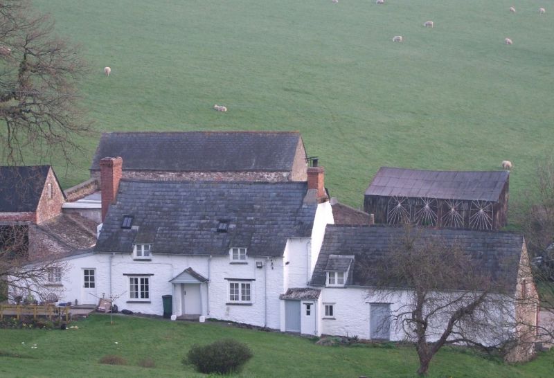
Probable origins as a C17 house, with later agricultural range to east; C20 lean-to extension to west end.
Small farmhouse; painted rubble with slate roof; end chimneys in brick. Entrance faces S, and has central doorway under open gabled porch; to each side, a 2-light window with casement glazing, above each of which is a small catslide dormer set across eaves. To R, a lower in-line block with doorway, and dormer with catslide roof. At L end, a projecting chimney breast with tall brick stack; modern lean-to extension. Ground falls away to rear where main block has, facing yard, 2 very small windows at eaves, set towards L, vertical ground floor window near centre, and a 2-light casement to its R. The lower block has pair of doorways to centre, with small window to R, and a very small window at eaves; lean-to block at right angles has corrugated roof covering.
Not available.
Included as farmhouse with good character and probable C17 origins.
External links are from the relevant listing authority and, where applicable, Wikidata. Wikidata IDs may be related buildings as well as this specific building. If you want to add or update a link, you will need to do so by editing the Wikidata entry.


Other nearby listed buildings
