Approximate Location Map
Large Map »
Latitude: 52.244 / 52°14'38"N
Longitude: 0.7141 / 0°42'50"E
OS Eastings: 585397
OS Northings: 264114
OS Grid: TL853641
Mapcode National: GBR QF0.7CH
Mapcode Global: VHKD4.BVDN
Plus Code: 9F426PV7+HM
Entry Name: 21, Hatter Street
Listing Date: 12 July 1972
Grade: II
Source: Historic England
Source ID: 1022534
English Heritage Legacy ID: 466904
ID on this website: 101022534
Location: Bury St Edmunds, West Suffolk, IP33
County: Suffolk
District: West Suffolk
Civil Parish: Bury St Edmunds
Built-Up Area: Bury St Edmunds
Traditional County: Suffolk
Lieutenancy Area (Ceremonial County): Suffolk
Church of England Parish: Bury St Edmunds St Mary
Church of England Diocese: St.Edmundsbury and Ipswich
Tagged with: Building
BURY ST EDMUNDS
TL8564SW HATTER STREET
639-1/14/429 (West side)
12/07/72 No.21
GV II
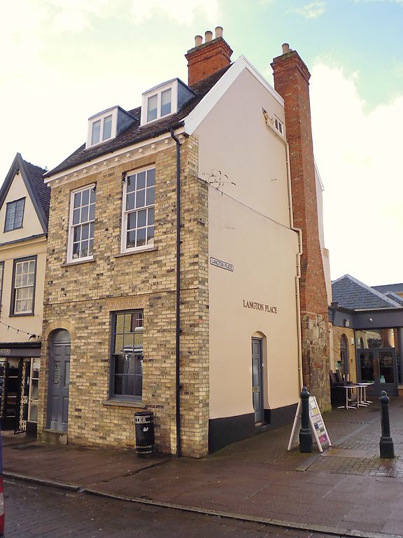
House, now a restaurant with living accommodation above. C18
and early C19 with fragmentary earlier core. White brick
front, rendered sides; steeply-pitched plaintiled roof with a
wood modillion eaves cornice along the front and 2 gables to
the side frontage.
EXTERIOR: 2 storeys, attics and cellar. 2 window range:
12-pane sashes in deep reveals with projecting stone sills and
flat gauged arches. A raised brick band above the
ground-storey windows. 2 flat-headed lead-covered dormers with
C20 2-light casement windows. Entrance door on left with 6
raised fielded panels, plain fanlight and a brick surround
with plain reveals and stilted arch. The side frontage has C20
shop windows and entrance door and an external chimney-stack
with a C12 stone base, moulded at the outer corners, which,
although fragmentary, appears to be in situ. The upper part of
the stack is in red brick.
INTERIOR: no internal features pre-date the C18: remains of a
dog-leg stair with turned balusters. The chimney-stack has 3
hearths, one on each storey, 2 with early C19 raised cast-iron
grates; the hearth in the attic has a surround of small old
Dutch tiles. From inside, it appears that the external
stonework is the side of the chimney-stack and that the
hearths are all at right-angles to it.
Listing NGR: TL8539764114
External links are from the relevant listing authority and, where applicable, Wikidata. Wikidata IDs may be related buildings as well as this specific building. If you want to add or update a link, you will need to do so by editing the Wikidata entry.


Other nearby listed buildings
