Latitude: 51.0623 / 51°3'44"N
Longitude: -1.7965 / 1°47'47"W
OS Eastings: 414357
OS Northings: 129232
OS Grid: SU143292
Mapcode National: GBR 51F.8MF
Mapcode Global: FRA 7639.ZXN
Plus Code: 9C3W3663+WC
Entry Name: 7, De Vaux Place
Listing Date: 12 October 1972
Grade: II
Source: Historic England
Source ID: 1023644
English Heritage Legacy ID: 319087
ID on this website: 101023644
Location: The Close, Wiltshire, SP1
County: Wiltshire
Civil Parish: Salisbury
Built-Up Area: Salisbury
Traditional County: Wiltshire
Lieutenancy Area (Ceremonial County): Wiltshire
Tagged with: Building
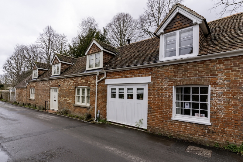
DE VAUX PLACE
1.
1594
No 7
SU 1429 SW 5/357A
II GV
2.
Single storey and attic red brick. Former service and stable wing of No 4
St Nicholas's Road qv. Gable end tiled roof 2 gabled dormers. 3 3-light renewed
casements replacing leaded casements. Door is lean-to at west end with radial
glazed fanlight. Modern garage doors replacing stable entry and 1 sash window
and glazed door now part of No 4 St Nicholas's Road.
No 7 forms a group with Nos 2 & 4 St Nicholas's Road.
Listing NGR: SU1434429235
External links are from the relevant listing authority and, where applicable, Wikidata. Wikidata IDs may be related buildings as well as this specific building. If you want to add or update a link, you will need to do so by editing the Wikidata entry.


Other nearby listed buildings