Latitude: 51.0622 / 51°3'43"N
Longitude: -1.7962 / 1°47'46"W
OS Eastings: 414378
OS Northings: 129228
OS Grid: SU143292
Mapcode National: GBR 51F.8PM
Mapcode Global: FRA 7649.S2V
Plus Code: 9C3W3663+VG
Entry Name: 2, St NICHOLAS'S ROAD (See details for further address information)
Listing Date: 28 February 1952
Grade: II*
Source: Historic England
Source ID: 1259072
English Heritage Legacy ID: 446164
ID on this website: 101259072
Location: The Close, Wiltshire, SP1
County: Wiltshire
Civil Parish: Salisbury
Built-Up Area: Salisbury
Traditional County: Wiltshire
Lieutenancy Area (Ceremonial County): Wiltshire
Tagged with: Building
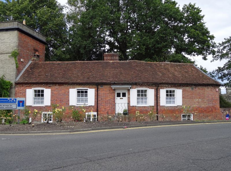
ST NICHOLAS'S ROAD
1.
1594 (West Side)
No 2
-
28.2.52. No 4
SU 1429 SW 5/357
II* GV
2.
No 2 former service rang of No 4. 1 storey and basement red brick with half
hipped old tile roof, brick eaves. Very early Cl9, 4 flush framed sashes,
glazing bars intact, with flush panelled shutters. Door of 6 flush panels
in plain surround approached at right angles by flight of stone steps with
wavy wrought iron guard rail. Flat hood on shaped brackets.
No 4 circa 1800. 3 storey. White brick. Strings at 1st and 2nd floor levels.
Moulded wood cornice and plain parapet with stone coping. 3 small windows
on 2nd floor. 2 large windows on lst floor and central angular bay with moulded
cornice and panelled apron. 2 similar windows on ground floor and central
6-Panel door in doorcase of delicately reeded pilasters, corner blocks, plain
frieze and moulded cornice with a dentilled bed mould, set in an elaborate
and delicate scroll pattern wrought iron porch under bay window.
Nos 2 and 4 form a group with No 7 De Vaux Place.
Listing NGR: SU1438329228
External links are from the relevant listing authority and, where applicable, Wikidata. Wikidata IDs may be related buildings as well as this specific building. If you want to add or update a link, you will need to do so by editing the Wikidata entry.


Other nearby listed buildings