Approximate Location Map
Large Map »
Latitude: 51.0685 / 51°4'6"N
Longitude: 0.6877 / 0°41'15"E
OS Eastings: 588400
OS Northings: 133347
OS Grid: TQ884333
Mapcode National: GBR QW3.STF
Mapcode Global: FRA D6B9.7QQ
Plus Code: 9F323M9Q+C3
Entry Name: 30, High Street
Listing Date: 8 June 1972
Grade: II
Source: Historic England
Source ID: 1025298
English Heritage Legacy ID: 179750
ID on this website: 101025298
Location: Tenterden, Ashford, Kent, TN30
County: Kent
District: Ashford
Civil Parish: Tenterden
Built-Up Area: Tenterden
Traditional County: Kent
Lieutenancy Area (Ceremonial County): Kent
Tagged with: Building
1.
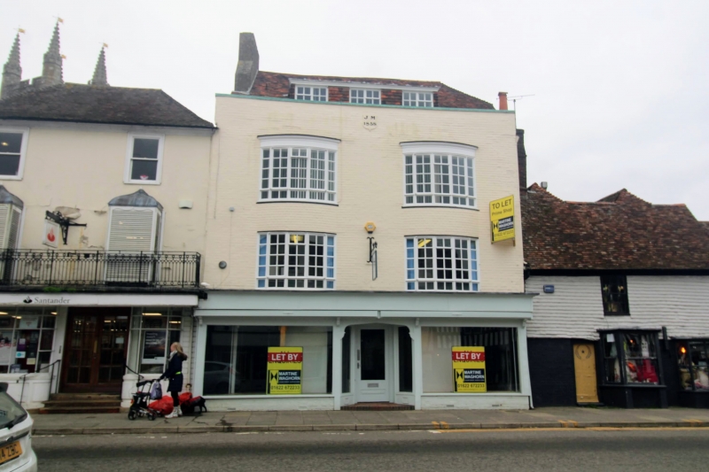
1715 HIGH STREET
(North Side)
No 30
TQ 8833 1/190
II GV
2.
Late C18. Dated 1858 with the initials JM, but this probably refers to some
alterations. 3 storeys and attics painted mathematical tiles. Tiled roof
with modern dormers. 2 modern curved bows on the 2 upper floors but with
modern glazing. Later shopfronts.
All the listed buildings on the north side from Nos 10 to 44, including
Church of St Mildred, form a group.
Listing NGR: TQ8839633349
External links are from the relevant listing authority and, where applicable, Wikidata. Wikidata IDs may be related buildings as well as this specific building. If you want to add or update a link, you will need to do so by editing the Wikidata entry.


Other nearby listed buildings
