Approximate Location Map
Large Map »
Latitude: 51.0683 / 51°4'5"N
Longitude: 0.6877 / 0°41'15"E
OS Eastings: 588404
OS Northings: 133318
OS Grid: TQ884333
Mapcode National: GBR QW3.STJ
Mapcode Global: FRA D6B9.7RX
Plus Code: 9F323M9Q+83
Entry Name: 35-41, High Street
Listing Date: 8 June 1972
Grade: II
Source: Historic England
Source ID: 1070371
English Heritage Legacy ID: 179718
ID on this website: 101070371
Location: Tenterden, Ashford, Kent, TN30
County: Kent
District: Ashford
Civil Parish: Tenterden
Built-Up Area: Tenterden
Traditional County: Kent
Lieutenancy Area (Ceremonial County): Kent
Tagged with: Building
1.
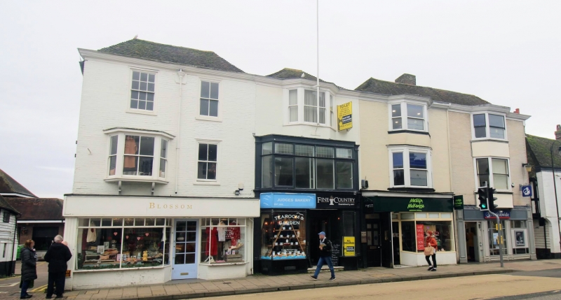
1715 HIGH STREET
(South Side)
Nos 35 to 41 (odd)
TQ 8833 1/183
II GV
2.
An early C19 range. 3 storeys painted brick. Hipped tiled roof with
moulded eaves cornice, 2 sashes to No 35, only 1 with glazing bars intact.
1 3 light bay to Nos 37, 39, 41. Modern shopfronts. No 35 has 1 3 light
bay on the 1st floor. Graded II for group value.
All the listed buildings on the South side from Nos 17 to 57 form a group.
Listing NGR: TQ8841133321
External links are from the relevant listing authority and, where applicable, Wikidata. Wikidata IDs may be related buildings as well as this specific building. If you want to add or update a link, you will need to do so by editing the Wikidata entry.


Other nearby listed buildings
