Latitude: 52.2419 / 52°14'30"N
Longitude: 0.7184 / 0°43'6"E
OS Eastings: 585699
OS Northings: 263898
OS Grid: TL856638
Mapcode National: GBR QF0.GGF
Mapcode Global: VHKD4.DXN6
Plus Code: 9F426PR9+Q9
Entry Name: 1, Sparhawk Street
Listing Date: 12 July 1972
Grade: II
Source: Historic England
Source ID: 1084195
English Heritage Legacy ID: 467508
ID on this website: 101084195
Location: Bury St Edmunds, West Suffolk, IP33
County: Suffolk
District: West Suffolk
Civil Parish: Bury St Edmunds
Built-Up Area: Bury St Edmunds
Traditional County: Suffolk
Lieutenancy Area (Ceremonial County): Suffolk
Church of England Parish: Bury St Edmunds St Mary
Church of England Diocese: St.Edmundsbury and Ipswich
Tagged with: Building
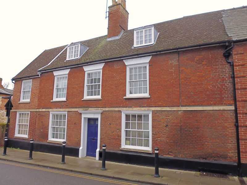
BURY ST EDMUNDS
TL8563NE SPARHAWK STREET
639-1/11/581 (East side)
12/07/72 No.1
GV II
House. Early C17 core, extended on the south in the C18; late
C18 front; a late C20 extension at the north end in matching
style. Timber-framed; faced in red brick; plastered rear with
traces of comb pargeting, but with the middle rail of the
frame and several widely-spaced studs exposed. These have
evidence of weathering. C20 plaintiled roof.
EXTERIOR: 2 storeys, attics and cellar: two-and-a-half bays. 3
window range: 16-pane sashes in flush cased frames, on the 1st
storey with wide flat gauged arches; on the ground storey with
the catches for former external shutters on each side. A
stucco band runs above the ground-storey windows and marks a
difference in the date and type of the brickwork: on the
ground-storey, Tudor brick laid in a random bond; above the
band, later bricks laid in a regular bonding. 2 flat-headed
lead-covered dormers have 2-light small-paned casement
windows.
A central 6-panelled door in a plain wood doorcase with
cornice. An internal chimney-stack with a plain rectangular
red brick shaft.
INTERIOR: basic jettied 2-cell plan with internal
chimney-stack and lobby entrance. The stack was tunnelled
through in the C18 to make a passage, now blocked. Main beams
with ovolo-moulding. The single-bay extension on the south is
marked by a slight change in the level of the brick front.
Listing NGR: TL8569963898
External links are from the relevant listing authority and, where applicable, Wikidata. Wikidata IDs may be related buildings as well as this specific building. If you want to add or update a link, you will need to do so by editing the Wikidata entry.


Other nearby listed buildings