Approximate Location Map
Large Map »
Latitude: 52.2421 / 52°14'31"N
Longitude: 0.7181 / 0°43'5"E
OS Eastings: 585674
OS Northings: 263913
OS Grid: TL856639
Mapcode National: GBR QF0.GC2
Mapcode Global: VHKD4.DXH3
Plus Code: 9F426PR9+R6
Entry Name: 10, Sparhawk Street
Listing Date: 12 July 1972
Last Amended: 30 October 1997
Grade: II
Source: Historic England
Source ID: 1145962
English Heritage Legacy ID: 467540
ID on this website: 101145962
Location: Bury St Edmunds, West Suffolk, IP33
County: Suffolk
District: West Suffolk
Civil Parish: Bury St Edmunds
Built-Up Area: Bury St Edmunds
Traditional County: Suffolk
Lieutenancy Area (Ceremonial County): Suffolk
Church of England Parish: Bury St Edmunds St Mary
Church of England Diocese: St.Edmundsbury and Ipswich
Tagged with: Building
BURY ST EDMUNDS
TL8563NE SPARHAWK STREET
639-1/11/589 (West side)
12/07/72 No.10
(Formerly Listed as:
SPARHAWK STREET
(West side)
Nos.9 AND 10)
GV II
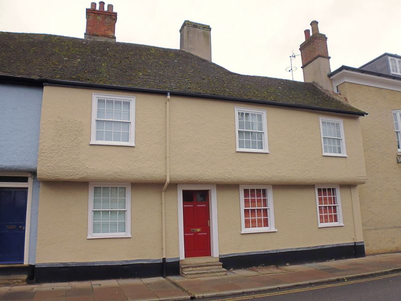
House. C16. Timber-framed and roughcast; C20 plaintiled roof.
Jettied along front; 3 bays with an additional bay at the
north end where the roof, originally with a hipped end, is at
a lower level.
EXTERIOR: 2 storeys and cellar; 3 window range: all sashes
with plate glass in flush cased frames. 4-panel door up steps,
with the top 2 panels glazed; wood surround with plain
reveals. A gabled rear wing.
INTERIOR: the main beams, with chamfers and curved stops, are
exposed on the ground storey. The room to the right of the
entrance, originally of 2 bays running back into the rear
gable, has a central beam supported on small solid brackets.
The end wall on the north was removed completely when the
extension was built.
The roof has its original rafters, including those of the hip,
but many later timbers have been introduced.
Listing NGR: TL8567463913
External links are from the relevant listing authority and, where applicable, Wikidata. Wikidata IDs may be related buildings as well as this specific building. If you want to add or update a link, you will need to do so by editing the Wikidata entry.


Other nearby listed buildings
