Approximate Location Map
Large Map »
Latitude: 53.3104 / 53°18'37"N
Longitude: -1.4606 / 1°27'38"W
OS Eastings: 436038
OS Northings: 379405
OS Grid: SK360794
Mapcode National: GBR LZ75.L1
Mapcode Global: WHDF2.J2P1
Plus Code: 9C5W8G6Q+4Q
Entry Name: Aston End
Listing Date: 9 January 1967
Grade: II*
Source: Historic England
Source ID: 1087766
English Heritage Legacy ID: 79511
ID on this website: 101087766
Location: Coal Aston, North East Derbyshire, S18
County: Derbyshire
District: North East Derbyshire
Civil Parish: Dronfield
Built-Up Area: Dronfield
Traditional County: Derbyshire
Lieutenancy Area (Ceremonial County): Derbyshire
Church of England Parish: Dronfield St John Baptist
Church of England Diocese: Derby
Tagged with: Architectural structure
PARISH OF DRONFIELD CROSS LANE
SK 37 NE
6/31
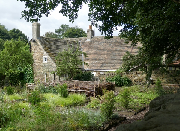
Aston End
II*
9.1.67
House. Medieval, with additions and alterations in C16, C17 and
C19. Coursed rubble coal measures sandstone with quoins, plain
gables, gable and ridge brick stacks and a stone slated roof.
L-plan house, comprising a three bay range to east and a two bay
crosswing to the east at the south end. The width of the
northern part of the main range has been increased to provide
small service rooms. Main range. West elevation, two storeys,
three bays, generally with 2-light C20 casements with leaded
lights, irregularly placed within the elevation. Two doorways,
one to the north end bay, the other to the centre, both within
plain openings undefined by dressings, and beneath modest
lintels. The door to the north end is half glazed, the central
door is planked and studded, both are C20. Crosswing range.
South elevation, two storeys, three bays, the gabled end of the
main range to the west end. Central doorway in a plain opening,
and C20 half glazed door. Above, a C20 gabled dormer with a
2-light casement window. To the east end, a 5-light recessed
chamfer mullioned window with C20 casements. To the west of the
doorway a single light C17 opening, and within the gable,
stacked 2-light casements, with flush stone frames. The ground
floor window is mullioned. Interior. The main range to the
west incorporates the substantial remains of an C16 hall, of at
least three bays, with king post roof trusses supporting a
single butt purlin roof. The truss to the centre of the house
is fully exposed, and has a cambered tie beam with hollow
chamfers to its lower edges, and a chamfered king post with
curved braces rising to support the ridge purlin. The soffits
of the tie beam, the principal rafters and the purlins to the
adjoining bays have nail head ornament, the tie beam has a
carved circular boss bearing a floral or fruit motif. These are
the remains of the close studded partitions in the south bay at
first floor level, and at ground floor level, between the main
range and the crosswing. The crosswing contains two full height
cruck trusses, which support single back purlins. The trusses
have collar and tie beams and a ridge purlin set square and
seated upon a yoke. Some windbraces survive.
Listing NGR: SK3603879405
External links are from the relevant listing authority and, where applicable, Wikidata. Wikidata IDs may be related buildings as well as this specific building. If you want to add or update a link, you will need to do so by editing the Wikidata entry.


Other nearby listed buildings
