Approximate Location Map
Large Map »
Latitude: 53.311 / 53°18'39"N
Longitude: -1.4572 / 1°27'25"W
OS Eastings: 436265
OS Northings: 379479
OS Grid: SK362794
Mapcode National: GBR LZ84.BT
Mapcode Global: WHDF2.L1BJ
Plus Code: 9C5W8G6V+C4
Entry Name: Range of Outbuildings to the East of Silkstone Farmhouse
Listing Date: 7 July 1989
Grade: II
Source: Historic England
Source ID: 1087775
English Heritage Legacy ID: 79536
ID on this website: 101087775
Location: Coal Aston, North East Derbyshire, S18
County: Derbyshire
District: North East Derbyshire
Civil Parish: Dronfield
Built-Up Area: Dronfield
Traditional County: Derbyshire
Lieutenancy Area (Ceremonial County): Derbyshire
Church of England Parish: Dronfield St John Baptist
Church of England Diocese: Derby
Tagged with: Building
PARISH OF DRONFIELD STONE ROAD
SK 37 NE
6/55
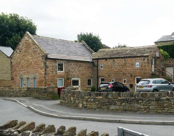
Range of outbuildings
to the east of
Silkstone Farmhouse
GV II
Farm outbuildings. Late C18 with C20 alterations. Coursed
squared coal measures sandstone, east range with coped gables
and moulded kneelers, south range with plain gables. Welsh
slates and stone slates. L-shaped range. South range, single
storey with overlofts, two bays, each bay with a doorway with
massive jambs, with bonding stones below deep lintels, and
planked stable doors. Above each doorway square overloft
windows with flush stone frames and 2-light windows. Between
the doorways, two square openings with flush surrounds and metal
bars, below which are openings with angled flagstones, giving
access to internal feeding troughs. Similar openings are to be
found on the rear elevation. East range advanced, two bays with
overloft. Central stable doorway beneath segmental arch,
planked stable door. Flanking square windows with deep lintels
and C20 garage door inserted into north gable. Feeding trough
openings below ground floor windows. Included for group value
only.
Listing NGR: SK3626579479
External links are from the relevant listing authority and, where applicable, Wikidata. Wikidata IDs may be related buildings as well as this specific building. If you want to add or update a link, you will need to do so by editing the Wikidata entry.


Other nearby listed buildings
