Latitude: 50.6214 / 50°37'16"N
Longitude: -4.6793 / 4°40'45"W
OS Eastings: 210571
OS Northings: 83613
OS Grid: SX105836
Mapcode National: GBR N4.B9VB
Mapcode Global: FRA 172F.JTC
Plus Code: 9C2QJ8CC+H7
Entry Name: 13, Fore Street
Listing Date: 13 January 1988
Grade: II
Source: Historic England
Source ID: 1137900
English Heritage Legacy ID: 68488
ID on this website: 101137900
Location: Camelford, Cornwall, PL32
County: Cornwall
Civil Parish: Camelford
Built-Up Area: Camelford
Traditional County: Cornwall
Lieutenancy Area (Ceremonial County): Cornwall
Church of England Parish: Lanteglos by Camelford
Church of England Diocese: Truro
Tagged with: Building
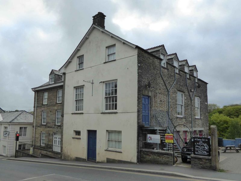
CAMELFORD FORE STREET (east side), Camelford
SX 1083 - 1183
8/46 No. 13
-
II
Hotel, now private club. Circa early C19 with earlier origins.
Stone rubble with ashlar facing to front elevation on left. Bitumen coated rag slate
roof with gable end on left and gable end to front wing on right. Ashlar stone stack
on right hand gable end of left hand range and ashlar stone stack in gable end of
front wing on right.
Original plan uncertain. The ground slopes steeply to the rear with a basement.
Overall 'L' shaped plan; the double-depth range on the left has a central entrance
with 2 large rooms on front, probably originally heated by end stacks. The front
wing to right has an entrance in the front gable end. There is a straight joint
between these 2 ranges.
3 storeys. Overall 3:2 window front. The left hand range is symmetrical and is
faced with ashlar stone with string courses and deep overhanging eaves; 3 window
front with dressed stone flat arches to openings. Ground floor with 2 tall 12-pane
horned sashes flanking C20 double doors in centre. Three 12-paned horned sashes on
first and second floors.
The right hand front wing is constructed of stone rubble with an ashlar stone facing
to the left hand side wall. Asymmetrical 2-window front elevation with C19 6-
panelled double doors and C20 fenestration on ground floor, two 16-pane horned sashes
on first floor and two 6-pane sashes on second floor. The fenestration in the right
hand side elevation has been altered and there are 3 gabled full dormers to the
attic.
Interior not inspected.
The club was formerly called the Indian King changing its name to the Higher Kings
Arms in 1735. A survey of 1757 refered to 'a house, malt house, pigs houses and
large yard with stable, barn and garden'. By the C19 the Inn was known as the King's
Arms.
Douch, H.L. Old Cornish Inns
Listing NGR: SX1057183613
External links are from the relevant listing authority and, where applicable, Wikidata. Wikidata IDs may be related buildings as well as this specific building. If you want to add or update a link, you will need to do so by editing the Wikidata entry.


Other nearby listed buildings