Approximate Location Map
Large Map »
Latitude: 54.5841 / 54°35'2"N
Longitude: -1.2284 / 1°13'42"W
OS Eastings: 449968
OS Northings: 521260
OS Grid: NZ499212
Mapcode National: GBR MHVF.VH
Mapcode Global: WHD70.31BL
Plus Code: 9C6WHQMC+JM
Entry Name: Transporter Bridge
Listing Date: 28 July 1988
Grade: II*
Source: Historic England
Source ID: 1139845
English Heritage Legacy ID: 59726
Also known as: Tees Transporter Bridge
Tranny
ID on this website: 101139845
Location: Middlesbrough, TS2
County: Middlesbrough
Electoral Ward/Division: Central
Built-Up Area: Middlesbrough
Traditional County: Yorkshire
Lieutenancy Area (Ceremonial County): North Yorkshire
Church of England Parish: Middlesbrough All Saints
Church of England Diocese: York
Tagged with: Steel bridge Transporter bridge
MIDDLESBROUGH FERRY ROAD,
NZ 42SE & NZ 52SW
(4921 & 5021) north end (off).
1/85 & 2/85 Transporter Bridge
G.V. II*
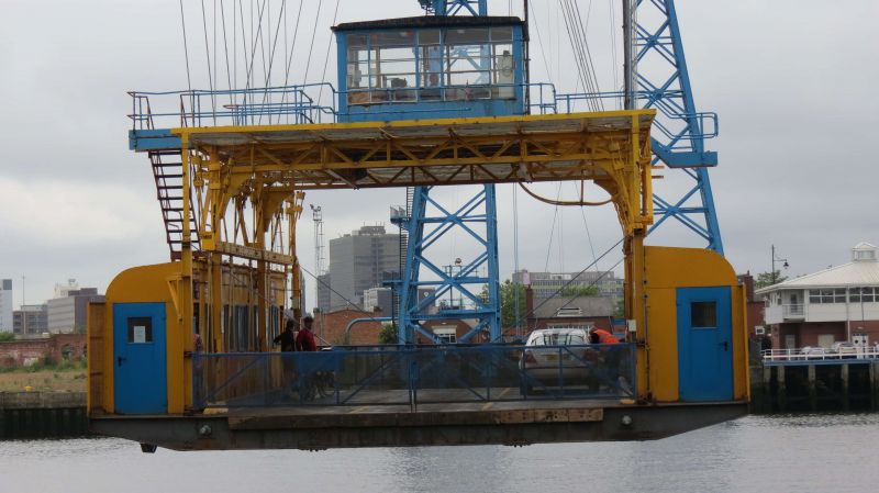
Transporter Bridge over River Tees, 1911 by G.C. Imbault (Cleveland Bridge
and Engineering Co.Ltd.) engineer; constructed by Sir William Arrol and
Company Limited (Glasgow). Opened by Prince Arthur of Connaught. Plated
and riveted steel. 2 pairs of tapering towers on steel and concrete
caissons, support main cantilevered trusses, of which lower chord carries
trolley way. Catwalk along trolley way 49m above water, and 260m. in
length, with 174m. span over river. Clusters of woven steel wire tension
ropes connect outward tips of trusses vertically down to concrete anchorage
blocks set into the ground. Carriage suspended on steel wire ropes, from
trolley hauled by 2 ropes connected to electrically powered winch, in
housing on south bank of river. Carriage damaged by enemy action in 1940.
Included in the list for the Borough of Stockton-on-Tees.
Listing NGR: NZ4996821260
This text is from the original listing, and may not necessarily reflect the current setting of the building.
External links are from the relevant listing authority and, where applicable, Wikidata. Wikidata IDs may be related buildings as well as this specific building. If you want to add or update a link, you will need to do so by editing the Wikidata entry.


Other nearby listed buildings
