Approximate Location Map
Large Map »
Latitude: 54.5825 / 54°34'56"N
Longitude: -1.2321 / 1°13'55"W
OS Eastings: 449725
OS Northings: 521080
OS Grid: NZ497210
Mapcode National: GBR MHVG.12
Mapcode Global: WHD70.12JT
Plus Code: 9C6WHQJ9+X4
Entry Name: Captain Cook Public House
Listing Date: 28 July 1988
Grade: II
Source: Historic England
Source ID: 1136730
English Heritage Legacy ID: 59714
Also known as: Captain Cook
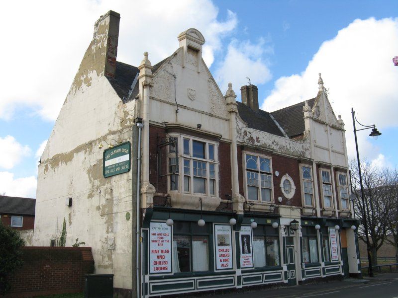
The Captain Cook, Middlesbrough
ID on this website: 101136730
Location: Port Clarence, Middlesbrough, North Yorkshire, TS2
County: Middlesbrough
Electoral Ward/Division: Central
Parish: Non Civil Parish
Built-Up Area: Middlesbrough
Traditional County: Yorkshire
Lieutenancy Area (Ceremonial County): North Yorkshire
Church of England Parish: Middlesbrough All Saints
Church of England Diocese: York
Tagged with: Pub
MIDDLESBROUGH DURHAM STREET,
NZ 42 SE (4921)
west side.
1/26 Captain Cook
public house.
- II.
Public house, dated 1893 in left gable, by Robert Moore (Middlesbrough)
Smooth red brick, rendered returns and stucco dressings. Painted stone
public house frontage. Slate roof. Jacobethan style with classical
features. 2 storeys, 6 bays. Ground-floor bays defined by pilasters under
fluted consoles. In 3rd bay, panelled double doors and overlight under 2
painted square panels, in panelled Ionic doorcase with enriched capitals and
segmental shell hood on enriched scrolled brackets with grotesque masks.
Renewed boarded double doors and overlight in vehicle entrance at right end.
Windows with moulded mullions and transoms and renewed glazing. Blind light
in each bay carries advertisement. Painted brick plinth. Frieze and dentil
cornice and late C20 lamp brackets between floors. Asymmetrical first floor
has 5 slightly-projecting mullioned-and-transomed windows, with sashes and
glazing bars, including oriel with quadrant angles and ogee oversailing,
flanked by engaged quasi-Ionic columns, at left end. Off-centre keyed
oculus. Central late C20 brewery sign. Continous cornice. Pilaster strips
flank 2 right end bays. Shaped gables, at ends, have pargeting with
foliage-enriched strapwork, blocked windows and ball finials on stems. Low
parapet, with corniced ramps at ends, runs between gables. Rendered end
stacks.
Listing NGR: NZ4972521080
External links are from the relevant listing authority and, where applicable, Wikidata. Wikidata IDs may be related buildings as well as this specific building. If you want to add or update a link, you will need to do so by editing the Wikidata entry.


Other nearby listed buildings
