Latitude: 52.2448 / 52°14'41"N
Longitude: 0.7156 / 0°42'56"E
OS Eastings: 585490
OS Northings: 264208
OS Grid: TL854642
Mapcode National: GBR QF0.7Q5
Mapcode Global: VHKD4.CV40
Plus Code: 9F426PV8+W6
Entry Name: 4, Angel Hill
Listing Date: 7 August 1952
Grade: II
Source: Historic England
Source ID: 1141154
English Heritage Legacy ID: 466623
ID on this website: 101141154
Location: Bury St Edmunds, West Suffolk, IP33
County: Suffolk
District: West Suffolk
Civil Parish: Bury St Edmunds
Built-Up Area: Bury St Edmunds
Traditional County: Suffolk
Lieutenancy Area (Ceremonial County): Suffolk
Church of England Parish: Bury St Edmunds St Mary
Church of England Diocese: St.Edmundsbury and Ipswich
Tagged with: Building
BURY ST EDMUNDS
TL8564SW ANGEL HILL 639-1/14/162 (West side) 07/08/52 No.4
GV II
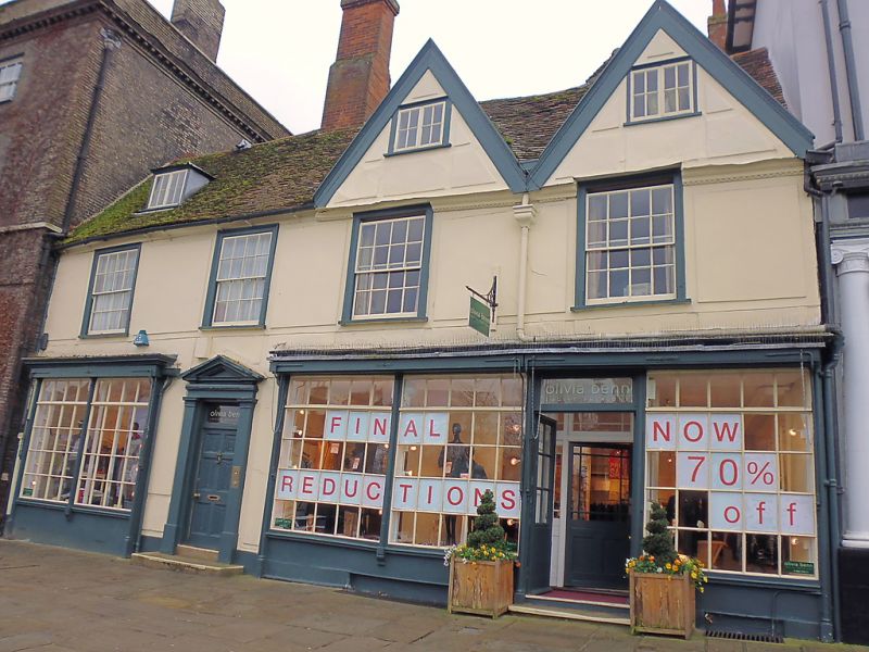
Shop with living accommodation above. C16, C18 and early C19. Timber-framed; rendered in raised rectangular panels; plaintile roof. EXTERIOR: 2 storeys, attics and cellar: 3-cell front range with internal chimney and former lobby-entrance; an C18 rear range at right-angles to it, forming an L which is partly infilled by an early C19 extension. The right half of the main roof has twin gables with plain bargeboards and a wide moulded eaves cornice below them. 4 window range: 16-pane sashes in flush cased frames. C20 shop fronts with small-paned windows in Regency style. 2 entrance doors, one to the shop, recessed, the other, on the left, 6-panelled with linenfold carving to the panels, plain pilasters and triangular pediment. A rear range, aligned east-west,has a mansard roof which tops over the front roof and 12-pane sash windows. The C19 extension is gabled with painted brick to the ground storey, roughcast above, and small-paned sash windows. INTERIOR: cellars below part of front and rear, all modernised. Original features are concealed in the front range on the ground storey, the rear wall has been partly removed and the chimney-stack tunnelled through to give access to the C19 extension. On the upper storey 2 rooms to the right of the stack have been made into one; a disused angle fireplace in the north-west corner. The main posts of the chimney-bay are exposed, with mortices for the former long braces. Clasped purlin roof in 6 bays with deep cambered collars. The C19 extension contains a winder stair with stick balusters and wreathed handrail. Several C18 6-panelled doors with raised fielded panels remain inside the building.
Listing NGR: TL8549064208
External links are from the relevant listing authority and, where applicable, Wikidata. Wikidata IDs may be related buildings as well as this specific building. If you want to add or update a link, you will need to do so by editing the Wikidata entry.


Other nearby listed buildings