Latitude: 52.245 / 52°14'41"N
Longitude: 0.7159 / 0°42'57"E
OS Eastings: 585512
OS Northings: 264228
OS Grid: TL855642
Mapcode National: GBR QF0.7TD
Mapcode Global: VHKD4.CTBW
Plus Code: 9F426PV8+X9
Entry Name: The Pillar of Salt Road Sign
Listing Date: 17 September 1998
Grade: II
Source: Historic England
Source ID: 1376516
English Heritage Legacy ID: 470518
ID on this website: 101376516
Location: Bury St Edmunds, West Suffolk, IP33
County: Suffolk
District: West Suffolk
Civil Parish: Bury St Edmunds
Built-Up Area: Bury St Edmunds
Traditional County: Suffolk
Lieutenancy Area (Ceremonial County): Suffolk
Church of England Parish: Bury St Edmunds St John the Evangelist
Church of England Diocese: St.Edmundsbury and Ipswich
Tagged with: Architectural structure Signpost
TL 8564 SE
639-1/8/10001
BURY ST EDMUNDS
ANGEL HILL
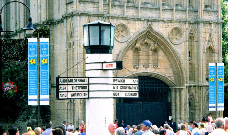
The Pillar of Salt Road Sign
GV
II
Road sign. 1935. By Basil Oliver, architect to Bury St Edmunds Town Council. Whitewashed concrete and metal. International Modern style.
Large octagonal pier has austere slightly oversailing lantern on top and projecting box-framed road signs in three directions. It stands on a plinth with steps and small corner octagonal piers. The 'Pillar of Salt', as it is known, forms the centre point of a very significant group of listed buildings and stands close to the former Abbey gatehouse.
HISTORY. The Town Council went to great lengths to find something worthy of this important location when increased motor traffic made signing essential. Basil Oliver advised on the design and at the time when road signs were being standardised under the 1933 Regulations, this sign is individual and probably unique. It was approved by the Ministry of Transport in June 1935 subject to the letters and road numbers being 5" high. This was a compromise since the new standard was for letters 4.5" high and numbers 6" high.
Listing NGR: TL8551264228
External links are from the relevant listing authority and, where applicable, Wikidata. Wikidata IDs may be related buildings as well as this specific building. If you want to add or update a link, you will need to do so by editing the Wikidata entry.


Other nearby listed buildings