Approximate Location Map
Large Map »
Latitude: 52.241 / 52°14'27"N
Longitude: 0.7123 / 0°42'44"E
OS Eastings: 585280
OS Northings: 263781
OS Grid: TL852637
Mapcode National: GBR QF0.DWX
Mapcode Global: VHKD4.9XDX
Plus Code: 9F426PR6+CW
Entry Name: 37 and 38, Westgate Street
Listing Date: 12 July 1972
Grade: II
Source: Historic England
Source ID: 1142319
English Heritage Legacy ID: 467683
ID on this website: 101142319
Location: Bury St Edmunds, West Suffolk, IP33
County: Suffolk
District: West Suffolk
Civil Parish: Bury St Edmunds
Built-Up Area: Bury St Edmunds
Traditional County: Suffolk
Lieutenancy Area (Ceremonial County): Suffolk
Church of England Parish: Bury St Edmunds St Mary
Church of England Diocese: St.Edmundsbury and Ipswich
Tagged with: Building
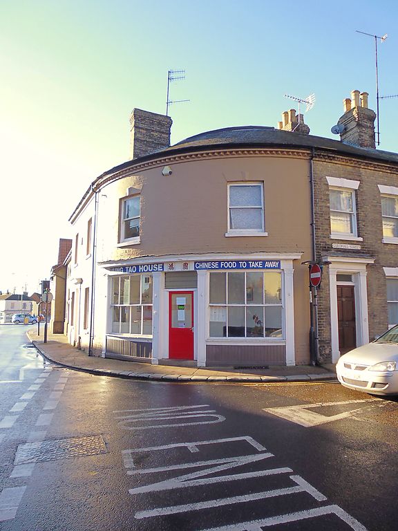
BURY ST EDMUNDS
TL8563NW WESTGATE STREET
639-1/15/675 (North side)
12/07/72 Nos.37 AND 38
GV II
House and shop. Mid C19. Painted brick with a slate roof and
wide eaves soffit. On a corner site with a quadrant corner;
forming part of the group with Nos 50 and 51 Guildhall Street
(qv).
EXTERIOR: 2 storeys and cellars; 4 window range: sashes
without glazing bars in plain reveals with flat arches and
keystones. No.37 has a central entrance with a 6-panel door
and rectangular fanlight in a doorcase with pilasters and flat
cornice hood. No.38 has a double shop front with 8-pane
windows divided by a transom and a central half-glazed shop
door.
Embedded in the south wall of No.37 is a pair of C14 timber
doorways with steeply arched heads, part of the timber-framed
range formerly on the corner of Westgate and St Andrew's
Street South. A continuation of the house to which they
belonged could possibly be concealed within the present
building.
INTERIOR: not inspected.
Listing NGR: TL8528063781
External links are from the relevant listing authority and, where applicable, Wikidata. Wikidata IDs may be related buildings as well as this specific building. If you want to add or update a link, you will need to do so by editing the Wikidata entry.


Other nearby listed buildings
