Latitude: 50.2152 / 50°12'54"N
Longitude: -5.2369 / 5°14'12"W
OS Eastings: 169171
OS Northings: 40033
OS Grid: SW691400
Mapcode National: GBR Z3.FFG4
Mapcode Global: VH12K.5VTF
Plus Code: 9C2P6Q87+37
Entry Name: Basset Count House
Listing Date: 12 September 1989
Grade: II
Source: Historic England
Source ID: 1142615
English Heritage Legacy ID: 66674
ID on this website: 101142615
Location: Carnkie, Cornwall, TR16
County: Cornwall
Civil Parish: Carn Brea
Traditional County: Cornwall
Lieutenancy Area (Ceremonial County): Cornwall
Church of England Parish: Redruth
Church of England Diocese: Truro
Tagged with: House
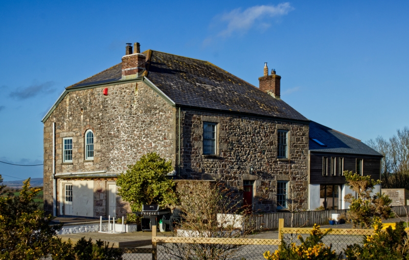
CARN BREA CARNKIE
SW 64 SE
5/126 Basset Count House
GV II
Count house to former Wheal Basset copper and tin mine. Later C19; altered and
extended. Uncoursed granite rubble with quoins, slurried slate roof. Rectangular
plan (except for recent additions on 3 sides). Three storeys except present
entrance front on south side where rising slope makes ground level at 1st floor,
and the wall is mostly covered by a modern 2-storey porch etc., leaving one 12-
pane sashed window on each floor at the right-hand end; the west end is
similarly covered at ground and 1st floor levels, but there are two 12-pane
sashes at 2nd floor, that on the right round-headed. On the north side the wall
has a vertical joint with quoins to the left half, a doorway and window to the
left of this, a ventilator and a tall round-headed window above, and to the right
a segmental-headed 12-pane sash on each upper floor. Additions to the east end.
Half-hipped roof, chimney at east end wall. Interior altered.
Listing NGR: SW6917140033
External links are from the relevant listing authority and, where applicable, Wikidata. Wikidata IDs may be related buildings as well as this specific building. If you want to add or update a link, you will need to do so by editing the Wikidata entry.


Other nearby listed buildings