Approximate Location Map
Large Map »
Latitude: 54.0539 / 54°3'14"N
Longitude: -2.8059 / 2°48'21"W
OS Eastings: 347335
OS Northings: 462296
OS Grid: SD473622
Mapcode National: GBR 8PVK.9J
Mapcode Global: WH846.WC0J
Plus Code: 9C6V353V+HJ
Entry Name: Three Warehouses, Now Part of Number 26, Maritime Museum
Listing Date: 18 February 1970
Last Amended: 13 March 1995
Grade: II
Source: Historic England
Source ID: 1195083
English Heritage Legacy ID: 383302
ID on this website: 101195083
Location: Lancaster, Lancashire, LA1
County: Lancashire
District: Lancaster
Electoral Ward/Division: Castle
Parish: Non Civil Parish
Built-Up Area: Lancaster
Traditional County: Lancashire
Lieutenancy Area (Ceremonial County): Lancashire
Church of England Parish: Lancaster St Mary with St John and St Anne
Church of England Diocese: Blackburn
Tagged with: Building
LANCASTER
SD4762 ST GEORGE'S QUAY
1685-1/3/267 (South West side)
18/02/70 Three warehouses, now part of No.26,
Maritime Museum
(Formerly Listed as:
ST GEORGE'S QUAY
No.26A)
GV II
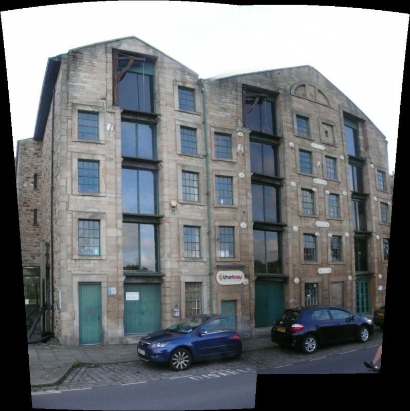
Three warehouses, now offices and an annexe to the adjoining
Maritime Museum (qv). Late C18, converted c1987. Right-hand
pair said to be 'lately erected' in a document dated 1788;
left-hand warehouse probably slightly later. Sandstone ashlar
in narrow courses to the front and coursed rubble to the sides
and rear. Slate roofs.
Right-hand warehouses form a mirrored pair with their gable to
the road, approx 23m deep and 12m wide. 5 storeys, each with a
central loading slot which has a plain stone surround, as do
all the openings. Each loading slot is flanked by windows with
fixed frames with glazing bars, except for the top and bottom
openings to the left of the right hand slot which are filled
by masonry. The top right-hand masonry panel is pierced by a
small opening and is a survival of an arrangement common in
warehouses in the quay; the other solid panels were replaced
by glazing in the late 1980s conversion. Placed centrally,
near the apex of the gable, an unglazed Diocletian window.
There is no opening in the outer bays of the top storey,
doubtless to strengthen the wall next to the crane which was
fixed in an offset recess in the loading slot. An original
wooden crane survives in the left-hand warehouse of the pair.
On the ground floor the outer bays contain low doorways. The
loading slots now have recessed glazing, but loading platforms
have been retained, supported on stone corbels. Iron
tie-plates are a late C20 addition to the facade.
The left-hand warehouse is approx 6m wide and has a single
gable facing the road. Its facade is almost identical to the
left-hand warehouse of the pair to its right. Its loading slot
is widened to the left on the top floor and retains its wooden
crane. At the left on the ground floor is a doorway. The
left-hand return wall was rebuilt following demolition of
adjoining property and is faced with sandstone rubble.
INTERIOR: wooden floors carried on timber beams, now encased
for fire protection. On the top floor the timber roofs are
exposed, with softwood tie beams and principals. The dividing
wall between the 2 right-hand warehouses is carried up to the
apex of the roof.
HISTORY: the 2 right-hand warehouses were built as a pair on
plots 41 & 42 by the merchants John Satterthwaite (plot 41)
who lived at 20 Castle Park (qv), and John Addison (plot 42),
who also built the left-hand warehouse on plot 40. All these
plots had originally been sold by the port commissioners in
1754 to Thomas Bowes, then in 1770 to William Gillison, whose
sister and heiress Anne sold them on again in 1781. A drawing
of the Quay made c1790 appears to show only the right-hand
pair of warehouses, but other details are inaccurate. A beam
in the left-hand warehouse was dated '1797'.
Listing NGR: SD4734362288
External links are from the relevant listing authority and, where applicable, Wikidata. Wikidata IDs may be related buildings as well as this specific building. If you want to add or update a link, you will need to do so by editing the Wikidata entry.


Other nearby listed buildings
