Latitude: 54.0542 / 54°3'15"N
Longitude: -2.8066 / 2°48'23"W
OS Eastings: 347289
OS Northings: 462326
OS Grid: SD472623
Mapcode National: GBR 8PVK.5F
Mapcode Global: WH846.VCPB
Plus Code: 9C6V353V+M8
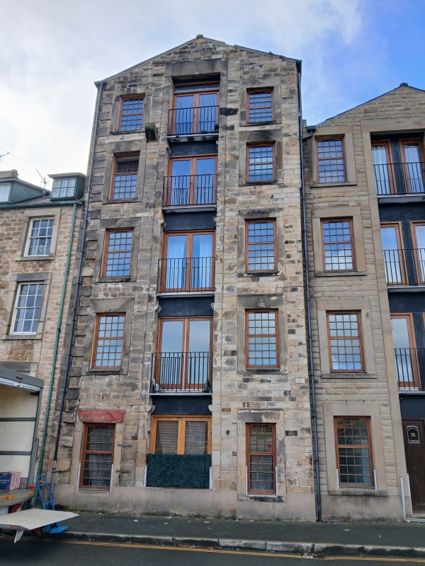
Entry Name: 35, St Georges Quay
Listing Date: 18 February 1970
Grade: II
Source: Historic England
Source ID: 1288858
English Heritage Legacy ID: 383306
ID on this website: 101288858
Location: Lancaster, Lancashire, LA1
County: Lancashire
District: Lancaster
Electoral Ward/Division: Castle
Parish: Non Civil Parish
Built-Up Area: Lancaster
Traditional County: Lancashire
Lieutenancy Area (Ceremonial County): Lancashire
Church of England Parish: Lancaster St Mary with St John and St Anne
Church of England Diocese: Blackburn
Tagged with: Building
LANCASTER
SD4762 ST GEORGE'S QUAY 1685-1/3/271 (South West side) 18/02/70 No.35
GV II
Warehouse. Late C18, with later alterations. Squared coursed sandstone with ashlar dressings to front and rubble to sides. Slate roof. Rectangular plan with gable to road. 5 storeys, with a central loading slot with plain stone surround and timber doors. Raised quoins to left. To each side of the loading slot there is a plain stone surround, filled with rubble. All those to the right, and that on the 1st floor at the left, contain smaller window openings with their own stone surrounds. On the ground floor there is a doorway with plain stone surround to each side.
Listing NGR: SD4728862324
External links are from the relevant listing authority and, where applicable, Wikidata. Wikidata IDs may be related buildings as well as this specific building. If you want to add or update a link, you will need to do so by editing the Wikidata entry.


Other nearby listed buildings