Approximate Location Map
Large Map »
Latitude: 53.7365 / 53°44'11"N
Longitude: -2.9661 / 2°57'58"W
OS Eastings: 336367
OS Northings: 427108
OS Grid: SD363271
Mapcode National: GBR 7TQ7.MB
Mapcode Global: WH85P.DBSX
Plus Code: 9C5VP2PM+HG
Entry Name: 17-25, Henry Street
Listing Date: 15 February 1993
Grade: II
Source: Historic England
Source ID: 1196372
English Heritage Legacy ID: 385282
ID on this website: 101196372
Location: Lytham, Fylde, Lancashire, FY8
County: Lancashire
District: Fylde
Electoral Ward/Division: Clifton
Parish: Non Civil Parish
Built-Up Area: Lytham St Anne's
Traditional County: Lancashire
Lieutenancy Area (Ceremonial County): Lancashire
Church of England Parish: Lytham St Cuthbert
Church of England Diocese: Blackburn
Tagged with: Building
LYTHAM ST ANNES
SD3627SW HENRY STREET, Lytham
621-1/5/66 (North side)
Nos.17-25 (Odd)
GV II
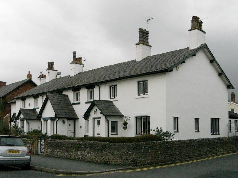
Row of 5 cottages with attached garden walls, now 4 dwellings.
Probably c.1840-50; altered. Scored stucco on cobble, with
sandstone dressings and slate roof. Double-depth plan, all
formerly single-fronted but Nos 21 and 23 now in one; No.25
set back at left end. Two low storeys, 2+2+2+2+2 windows. Nos
17, 23 and 25 have small gabled porches (that to No.25 set
into re-entrant angle at junction); Nos 19 and 21 share a
taller gabled porch with doorways in the side walls (that to
No.21 altered as a window) and 2-light mullioned windows in
the front. All have one 3-light mullioned window at ground
floor and 2 small 2-light windows at 1st floor, all with
raised sills and chamfered lintels. Ridge chimneys.
The attached garden walls in front and along the east returned
end of the plot are of slobbered cobble (but that to No.21 and
23 unsympathetically rendered recently), approx.1 metre high;
the returned side rises to approx. 2 metres high at the rear
corner of the block, and is of cobble interlaced with red
brick.
Listing NGR: SD3636727108
External links are from the relevant listing authority and, where applicable, Wikidata. Wikidata IDs may be related buildings as well as this specific building. If you want to add or update a link, you will need to do so by editing the Wikidata entry.


Other nearby listed buildings
