Approximate Location Map
Large Map »
Latitude: 51.6713 / 51°40'16"N
Longitude: 0.3861 / 0°23'10"E
OS Eastings: 565097
OS Northings: 199641
OS Grid: TQ650996
Mapcode National: GBR NJW.2G4
Mapcode Global: VHJKD.N804
Plus Code: 9F32M9CP+GF
Entry Name: 25, High Street
Listing Date: 20 February 1976
Last Amended: 9 December 1994
Grade: II
Source: Historic England
Source ID: 1197291
English Heritage Legacy ID: 373658
ID on this website: 101197291
Location: Ingatestone, Brentwood, Essex, CM4
County: Essex
District: Brentwood
Civil Parish: Ingatestone and Fryerning
Built-Up Area: Ingatestone
Traditional County: Essex
Lieutenancy Area (Ceremonial County): Essex
Church of England Parish: Ingatestone St Edmund and St Mary
Church of England Diocese: Chelmsford
Tagged with: Building
INGATESTONE AND FRYERNING
TQ6599 HIGH STREET, Ingatestone
723-1/14/376 (South East side)
20/02/76 No.25
(Formerly Listed as:
BRENTWOOD .
HIGH STREET, Ingatestone (South East side)
No. 25 )
GV II
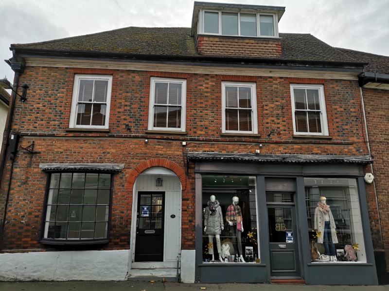
House, now shops and flat. Early C18, extended in C19 and C20. Red and blue bricks in Flemish bond, roofed with concrete tiles. Rectangular plan facing
NW with internal stack at left side and originally external stack at rear
middle. Two 2-storey adjacent wings to rear left, with a lean-to conservatory beyond the right wing. 2-storey extension to rear right, forming a catslide
with the main roof, and C20 single-storey extension beyond, with flat roof.
2 storeys with attics. Ground floor. C20 bow window of 20 lights at left, in early C19 style. At right there has been an early C19 double bow shopfront,
now replaced by C20 shopfront with central half-glazed door, leaving the
earlier moulded fascia and mutuled cornice in situ. Recessed doorway to left
of centre with semicircular arch of gauged red brick; C20 half-glazed door. 2 stone steps. First floor, four C19 sashes of 4 lights in original apertures
with flat arches of gauged red brick. C20 dormer in roof, to right of centre, with casements on 32 sides and flat roof. The blue headers form a regular pattern. Raised band of one course of red brick immediately below the sills
of the first-floor windows. Moulded wooden eaves cornice. Roof hipped at left end. In the left return, at half-floor level, is an original double casement,
the frame of jointed and rebated hardwood, the right half blocked, the left casement renewed; segmental brick arch. About 2.50m above the ground is a
brick inscribed 'I. F. 1720', probably the date of construction. Blue headers form a regular pattern, as at the front. The left wall of the left rear wing
is of similar brickwork on the ground floor, cement render above. Near the
rear corner, about 1.50m above the ground, is a brick inscribed 'I. N 1737',
and later graffiti. Shaped sprockets below the eaves. The rear elevation is roughcast rendered. In the main roof is a gabled dormer with C20 casement.
At rear right, on the first floor, is a wide picture window, with smaller
window in the right return, and a C20 half-glazed door. Other rear windows
are C20 casements.
Listing NGR: TQ6509799641
External links are from the relevant listing authority and, where applicable, Wikidata. Wikidata IDs may be related buildings as well as this specific building. If you want to add or update a link, you will need to do so by editing the Wikidata entry.


Other nearby listed buildings
