Latitude: 53.3723 / 53°22'20"N
Longitude: -3.0006 / 3°0'2"W
OS Eastings: 333524
OS Northings: 386630
OS Grid: SJ335866
Mapcode National: GBR 7YHF.5T
Mapcode Global: WH87D.WHBK
Plus Code: 9C5R9XCX+WQ
Entry Name: Numbers 5 and 6 with Gatepiers to Front Garden
Listing Date: 13 March 1973
Grade: II
Source: Historic England
Source ID: 1201760
English Heritage Legacy ID: 389313
ID on this website: 101201760
Location: Rock Park, Wirral, Merseyside, CH42
County: Wirral
Electoral Ward/Division: Rock Ferry
Parish: Non Civil Parish
Built-Up Area: Birkenhead
Traditional County: Cheshire
Lieutenancy Area (Ceremonial County): Merseyside
Church of England Parish: Rock Ferry St Peter
Church of England Diocese: Chester
Tagged with: Building
BIRKENHEAD
SJ3386 ROCK PARK, Rock Ferry 789-1/12/253 (East side) 13/03/73 Nos.5 AND 6 with gatepiers to front garden
GV II
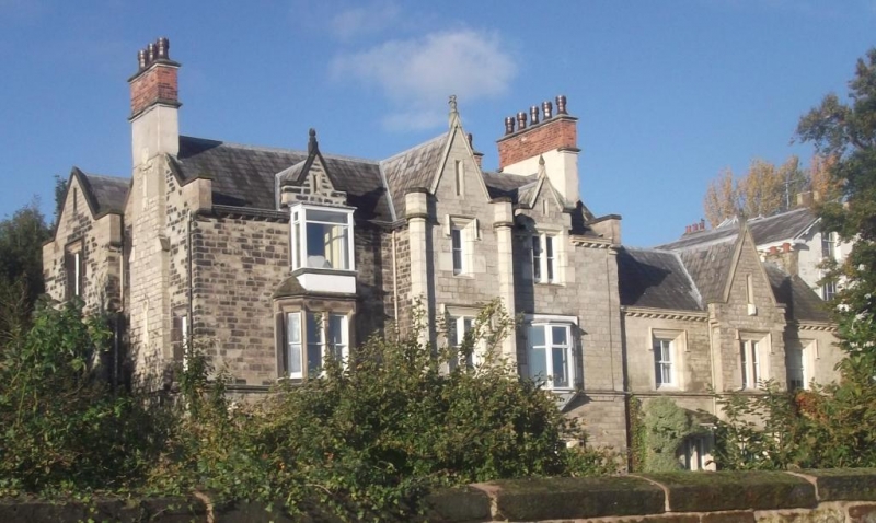
Pair of houses. c1836. Coursed and squared rubble with Welsh slate roof. Picturesque gothick style, asymmetrically-planned. On street side, No.5 forms a single-storey, with 2 ranges with semi-circular bay carried on corbels in their angle. Gabled porch with 4-centred arch over plank door and earlier C20 gabled extension to right. 2 storeys to elevation facing Esplanade, symmetrically-planned of 3 bays with central narrow advanced gable over hallway. Paired part glazed doors in 4-centred arch way with hood mould over. Large canted bay window to left, the other windows all renewed in original openings with hood moulds. Corbelled eaves course. Coped gables and gable end stacks. No.6 comprises 2 parallel ranges with central entrance to street front in coped gabled porch with projecting stack to right and small mullioned windows to left. 3 gabled dormers above. Exaggerated kneelers to all gables. 3-storeyed 3-bay elevation to Esplanade with central advanced narrow gable stressed by octagonal pilasters. Paired part-glazed doors in 4-centred arch with hood mould over. 2-storey canted bay window to left with newer bay added in upper storey. 2-light mullioned windows in right hand bay with renewed oriel window to first floor. Paired octagonal gate piers to street elevation with stepped pyramidal caps. The houses form part of the original Rock Park development laid out by J. Bennison in 1836. (The Buildings of England: Pevsner N and Hubbard E: Cheshire: Harmondsworth: 1971-).
Listing NGR: SJ3352486630
External links are from the relevant listing authority and, where applicable, Wikidata. Wikidata IDs may be related buildings as well as this specific building. If you want to add or update a link, you will need to do so by editing the Wikidata entry.


Other nearby listed buildings