Latitude: 53.3719 / 53°22'18"N
Longitude: -3.0001 / 3°0'0"W
OS Eastings: 333557
OS Northings: 386586
OS Grid: SJ335865
Mapcode National: GBR 7YHF.8Z
Mapcode Global: WH87D.WHKV
Plus Code: 9C5R9XCX+QX
Entry Name: 8 9, Rock Park
Listing Date: 13 March 1973
Grade: II
Source: Historic England
Source ID: 1282515
English Heritage Legacy ID: 389315
ID on this website: 101282515
Location: Rock Park, Wirral, Merseyside, CH42
County: Wirral
Electoral Ward/Division: Rock Ferry
Parish: Non Civil Parish
Built-Up Area: Birkenhead
Traditional County: Cheshire
Lieutenancy Area (Ceremonial County): Merseyside
Church of England Parish: Rock Ferry St Peter
Church of England Diocese: Chester
Tagged with: Building
BIRKENHEAD
SJ3386 ROCK PARK, Rock Ferry
789-1/12/255 (East side)
13/03/73 Nos.8 AND 9
GV II
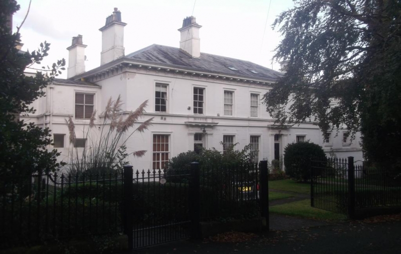
Pair of houses. c1836. Stucco with Welsh slate hipped roof.
2-storeys with attic and basement. 6-window range, divided
into 2 apparently symmetrical units, each with double-pile
plan and central door. Internally, the plans interlock, each
house having 3 principal rooms on each floor. No.8 has two
rooms to rear and one to front and entrance hall to right, and
No.9 with central entrance hall, 2 front rooms and one to
rear. Neo-classical style. 2-panelled doors with overlights in
architraves with triglyph frieze and balustraded cornice.
16-pane sash windows to ground floor, one partly replaced with
casement. Upper windows are 12 and 8-pane sashes, and all
windows have moulded architraves an continuous sill bands.
Modillion eaves cornice, end and axial stacks. Recessed each
side are full-height service bays which incorporate stable and
coach house in the basement of No.9. Elevation to Esplanade
has canted bay windows flanking 8-pane sash windows. Gate
piers to No.9 on street front, squared posts with round-arched
panelled decoration and ribbed caps. The houses form part of
the original Rock Park development laid out by J.Bennison in
1836.
(The Buildings of England: Pevsner N and Hubbard E: Cheshire:
Harmondsworth: 1971-).
Listing NGR: SJ3355786586
External links are from the relevant listing authority and, where applicable, Wikidata. Wikidata IDs may be related buildings as well as this specific building. If you want to add or update a link, you will need to do so by editing the Wikidata entry.


Other nearby listed buildings