Latitude: 54.0511 / 54°3'3"N
Longitude: -2.8031 / 2°48'11"W
OS Eastings: 347520
OS Northings: 461978
OS Grid: SD475619
Mapcode National: GBR 8PVL.YK
Mapcode Global: WH846.XFDQ
Plus Code: 9C6V352W+CQ
Entry Name: The Three Mariners Public House
Listing Date: 18 February 1970
Last Amended: 13 March 1995
Grade: II
Source: Historic England
Source ID: 1220003
English Heritage Legacy ID: 383053
Also known as: Three Mariners
The Three Mariners, Lancaster
ID on this website: 101220003
Location: Lancaster, Lancashire, LA1
County: Lancashire
District: Lancaster
Electoral Ward/Division: Castle
Parish: Non Civil Parish
Built-Up Area: Lancaster
Traditional County: Lancashire
Lieutenancy Area (Ceremonial County): Lancashire
Church of England Parish: Lancaster St Mary with St John and St Anne
Church of England Diocese: Blackburn
Tagged with: Pub
LANCASTER
SD4761NE BRIDGE LANE 1685-1/7/18 The Three Mariners Public House 18/02/70 (Formerly Listed as: BRIDGE LANE Carpenters' Arms Hotel)
II
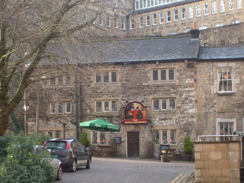
Public house. Late C17, with C19 addition, altered and restored early C20. Coursed sandstone rubble with slate roof and brick chimneys. Rectangular 3-unit plan, with a Single-storey addition on the right. The original building has 3 storeys and 3 bays and gable chimneys. The doorway between bays 2 and 3 has a restored chamfered surround including a shaped lintel. The windows are mostly restored and have flush chamfered mullions on the ground floor and chamfered mullions in rebated and chamfered surrounds above. All are of 3 lights except for a 2-light window in the 2nd bay on the ground floor. The C19 extension has a shallow-pitched roof and a gable chimney; it is of a full height but has only 2 storeys. It has on the right a tall doorway with a plain surround and overlight, and a large 6-paned sash window on each floor. INTERIOR: the third unit has 2 large roughly chamfered axial beams; the remainder has roughly-shaped lateral beams, but the positions of all suggest alterations which may have included the removal of a former axial chimney stack. HISTORY: Bridge Lane was the main road leading north over the Lune until Skerton Bridge was built in 1788. Most of the remaining part of the street was demolished when a new road from China Street to the Bus Station was made in 1937. Old photographs, one dated 1927, show that the present facade, which once formed part of a row of buildings, is largely restored. They show a gabled 4th storey above the 2 right-hand bays, and a ground-floor doorway in the left-hand bay.
Listing NGR: SD4752061978
External links are from the relevant listing authority and, where applicable, Wikidata. Wikidata IDs may be related buildings as well as this specific building. If you want to add or update a link, you will need to do so by editing the Wikidata entry.


Other nearby listed buildings