Approximate Location Map
Large Map »
Latitude: 51.8092 / 51°48'33"N
Longitude: -1.6373 / 1°38'14"W
OS Eastings: 425104
OS Northings: 212346
OS Grid: SP251123
Mapcode National: GBR 5SW.DX7
Mapcode Global: VHBZS.KSSF
Plus Code: 9C3WR957+M3
Entry Name: Burford Primary School Together with Forecourt Wall and Railings
Listing Date: 1 March 1990
Grade: II
Source: Historic England
Source ID: 1224756
English Heritage Legacy ID: 420901
ID on this website: 101224756
Location: Burford, West Oxfordshire, OX18
County: Oxfordshire
District: West Oxfordshire
Civil Parish: Burford
Built-Up Area: Burford
Traditional County: Oxfordshire
Lieutenancy Area (Ceremonial County): Oxfordshire
Church of England Parish: Burford
Church of England Diocese: Oxford
Tagged with: Architectural structure
BURFORD AND UPTON PRIORY IANE
AND SIGNET (North side)
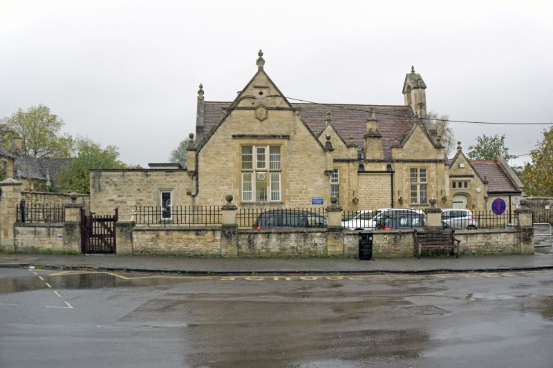
SP2512 (Enlargement) Burford Primary School
7/65 together with fore-
court wall and
railings.
GV II
Primary school and boundary wall and railings. Dated 1877. Coursed and
squared rubble, plain tile roof. Vernacular style-see the coped gables
with steps (party traceried), the cut and shaped finials, the mullioned
windows with transoms and cornices. Single storey. 3 gables to front,
the left-hand gable projects by one bay and is wider with corbelled
finials, 3-light window, string between gable steps with lozenge date
panel. The two right-hand gables break through the eaves and have side
pilasters with ball - finials; they flank a broached chimney with diagonal
shaft (base only). Base of diagonal-shafted chimney - pair at junction of
ridges. Heavy bellcote to east gable with arched opening. Entered from
low extension with gable to left over moulded elliptical-head doorway and
the 3-light transom window with cornice, corbelled ball-finials, extended
by short bay to right.
The boundary wall is in rubble and has chamfered coping with wall-
buttresses carrying ball-copped dies, short railings with flattened heads
between and 3 gateways. Railings link school and wall.
Listing NGR: SP2510412346
External links are from the relevant listing authority and, where applicable, Wikidata. Wikidata IDs may be related buildings as well as this specific building. If you want to add or update a link, you will need to do so by editing the Wikidata entry.


Other nearby listed buildings
