Approximate Location Map
Large Map »
Latitude: 53.5394 / 53°32'21"N
Longitude: -2.6985 / 2°41'54"W
OS Eastings: 353805
OS Northings: 404977
OS Grid: SD538049
Mapcode National: GBR 9WLH.LY
Mapcode Global: WH86S.J96G
Plus Code: 9C5VG8Q2+QH
Entry Name: The Mount Public House
Listing Date: 15 December 1977
Grade: II
Source: Historic England
Source ID: 1228430
English Heritage Legacy ID: 403037
Also known as: Mount
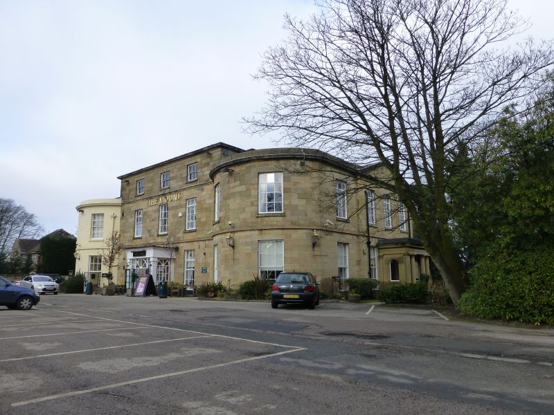
The Mount, Wigan
ID on this website: 101228430
Location: Orrell, Wigan, Greater Manchester, WN5
County: Wigan
Electoral Ward/Division: Orrell
Parish: Non Civil Parish
Built-Up Area: Wigan
Traditional County: Lancashire
Lieutenancy Area (Ceremonial County): Greater Manchester
Church of England Parish: Pemberton St John
Church of England Diocese: Liverpool
Tagged with: Pub
ORRELL ORRELL ROAD
SD 50 SW
(north side)
8/100 Nos. 160 and
162 (The Mount
15.12.77 Public House)
- II
House, now public house. Early C19. Stone with extension of
stucco with stone dressings, hipped roofs. 3-storey, 3-bay
centre with 2-storey, 2-bay bowed wings, and further
recessed 2-storey bay to left. Band over ground floor;
cornice over 1st floor with blocking courses to wings; attic
has cornice. Windows are mostly sashed with glazing bars;
some ground-floor windows altered. Plain central open porch,
probably later. Right return of 5 bays, 3-bay centre breaks
forward under pediment. Central porch has Tuscan columns,
pulvinated frieze to entablature and round-headed openings
to sides. Interior being altered (1986) so only partially
inspected, one hall said to have gone as have fireplaces.
Remaining hall has enriched barrel vaulted ceiling, open-
well stair with iron balusters and some 6-panel doors. Used
by exiled French Benedictine Nuns in early C19.
Listing NGR: SD5380504977
External links are from the relevant listing authority and, where applicable, Wikidata. Wikidata IDs may be related buildings as well as this specific building. If you want to add or update a link, you will need to do so by editing the Wikidata entry.


Other nearby listed buildings
