Approximate Location Map
Large Map »
Latitude: 54.2311 / 54°13'52"N
Longitude: -0.7224 / 0°43'20"W
OS Eastings: 483377
OS Northings: 482465
OS Grid: SE833824
Mapcode National: GBR RMDJ.D0
Mapcode Global: WHF9X.WX57
Plus Code: 9C6X67JH+C2
Entry Name: Bleach Mill Farmhouse
Listing Date: 5 February 1986
Grade: II
Source: Historic England
Source ID: 1241305
English Heritage Legacy ID: 440237
ID on this website: 101241305
Location: Thornton-le-Dale, North Yorkshire, YO18
County: North Yorkshire
District: Ryedale
Civil Parish: Thornton-le-Dale
Built-Up Area: Thornton-le-Dale
Traditional County: Yorkshire
Lieutenancy Area (Ceremonial County): North Yorkshire
Tagged with: Farmhouse
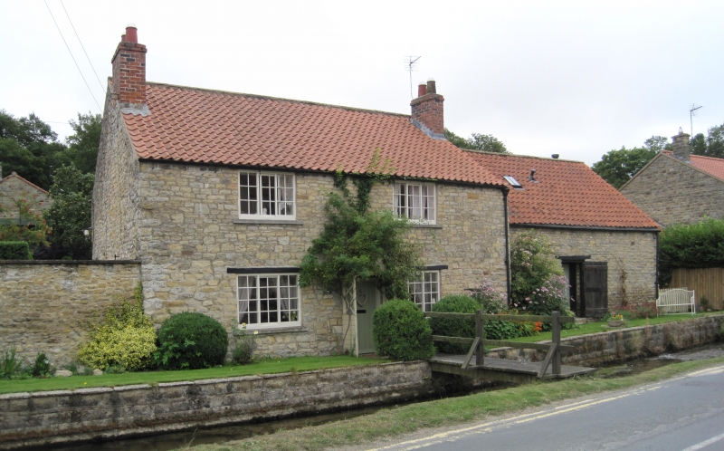
THORNTON DALE MALTONGATE
SE 8382
(east side)
15/130 Bleach Mill Farmhouse
GV
II
House and attached outbuilding. Mid C18. Coursed sandstone rubble; pantile
roof; brick stacks. Central staircase plan. 2-storey, 2-window front to
house, with single storey outbuilding to right. Central board door to
house, and similar door to centre of outbuilding. 3-light, small-pane
horizontal sliding sashes with stone sills to house; fixed-light firewindow
to end right. Timber lintels to all ground floor openings. Outbuilding
gable end to right: pitching window with pigeoncote above. End stacks to
house.
Listing NGR: SE8337782465
External links are from the relevant listing authority and, where applicable, Wikidata. Wikidata IDs may be related buildings as well as this specific building. If you want to add or update a link, you will need to do so by editing the Wikidata entry.


Other nearby listed buildings
