Approximate Location Map
Large Map »
Latitude: 52.2496 / 52°14'58"N
Longitude: 0.7148 / 0°42'53"E
OS Eastings: 585419
OS Northings: 264742
OS Grid: TL854647
Mapcode National: GBR QDT.TTF
Mapcode Global: VHKD4.BQR9
Plus Code: 9F426PX7+RW
Entry Name: St Edmunds Head Public House and Stable Block
Listing Date: 12 July 1972
Last Amended: 30 October 1997
Grade: II
Source: Historic England
Source ID: 1248044
English Heritage Legacy ID: 466692
ID on this website: 101248044
Location: Bury St Edmunds, West Suffolk, IP33
County: Suffolk
District: West Suffolk
Civil Parish: Bury St Edmunds
Built-Up Area: Bury St Edmunds
Traditional County: Suffolk
Lieutenancy Area (Ceremonial County): Suffolk
Church of England Parish: Bury St Edmunds St John the Evangelist
Church of England Diocese: St.Edmundsbury and Ipswich
Tagged with: Pub
BURY ST EDMUNDS
TL8564NW CANNON STREET, Pea Porridge Green
639-1/3/227 (East side)
12/07/72 No.86
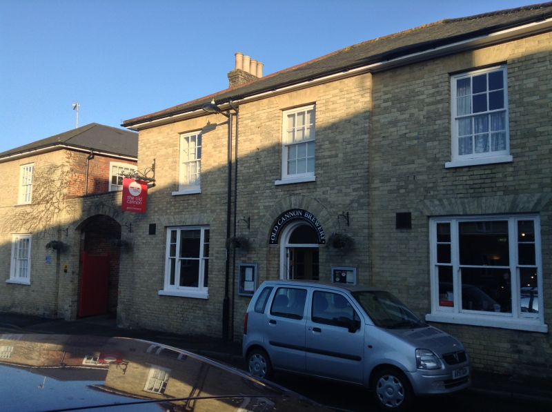
St Edmund's Head Public House and
stable block
(Formerly Listed as:
CANNON STREET, Pea Porridge Green
(East side)
St Edmund's Head Public House)
(Formerly Listed as:
CANNON STREET, Pea Porridge Green
(East side)
Stable Block to St Edmund's Head
Public House)
II
Public house with an attached former stable block. Mid C19.
White brick front, red brick sides and rear; hipped slate
roof.
EXTERIOR: 2 storeys and cellars. 3 window range, arranged
1:1:1, with the centre breaking forward slightly. Small-paned
sashes in plain reveals to the 1st storey and 3-light sashes
with diminished side lights and clear glass to the ground
storey. A central 6-panelled door with semicircular fanlight
is set in a brick arched recess with the inner arch plastered.
The 2-storey stable range to the north, in the same materials
as the main building, is linked to it by a wall with a
segmental-arched carriage entrance. Set at right-angles to the
road, it had stabling for 24 horses with sleeping
accommodation above, but is now fully converted to
living-accommodation. One tripartite small-paned sash window
on the west front, and a 5-window range, arranged 3:2 along
the south side. The complex is situated on the east side of
Pea Porridge Green.
Listing NGR: TL8541964742
External links are from the relevant listing authority and, where applicable, Wikidata. Wikidata IDs may be related buildings as well as this specific building. If you want to add or update a link, you will need to do so by editing the Wikidata entry.


Other nearby listed buildings
