Latitude: 52.25 / 52°14'59"N
Longitude: 0.7146 / 0°42'52"E
OS Eastings: 585401
OS Northings: 264780
OS Grid: TL854647
Mapcode National: GBR QDT.TQQ
Mapcode Global: VHKD4.BQM1
Plus Code: 9F426PX7+XR
Entry Name: 37, 38 and 39, Cannon Street
Listing Date: 12 July 1972
Grade: II
Source: Historic England
Source ID: 1248040
English Heritage Legacy ID: 466689
ID on this website: 101248040
Location: Bury St Edmunds, West Suffolk, IP33
County: Suffolk
District: West Suffolk
Civil Parish: Bury St Edmunds
Built-Up Area: Bury St Edmunds
Traditional County: Suffolk
Lieutenancy Area (Ceremonial County): Suffolk
Church of England Parish: Bury St Edmunds St John the Evangelist
Church of England Diocese: St.Edmundsbury and Ipswich
Tagged with: Building
BURY ST EDMUNDS
TL8564NW CANNON STREET, Pea Porridge Green
639-1/3/224 (West side)
12/07/72 Nos.37, 38 AND 39
GV II
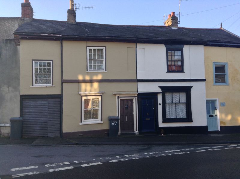
A row of 3 houses. C13 core with C17 and later alterations;
early C19 fronts to Nos 37 and 38; modernised exterior to
No.39. Timber-framed and rendered; slate roofs.
EXTERIOR: 2 storeys. The centre of the range has 2 16-pane
sashes in flush cased frames on the upper storey with a blank
between, and 2 large-paned sashes on the ground storey, that
on the right a former shop window. A raised stucco band runs
between the storeys. Paired doors to Nos 37 and 38 are C20
replacements in early C19 moulded architraves with plain
cornice hoods. The 2 outer ends of the row have upper windows
at a lower level than the centre, a 16-pane sash on the left
with a wide carriage entrance underneath and a large-paned C20
sash on the right above a C20 door. A single-storey extension
to the north stretches round the corner.
INTERIOR: Nos 37 and 38 contain the fragmentary remains of a
C13 aisled house with a 2-bay open hall and a storied end to
the south of it. One of the main beams which supported the
upper floor of the storeyed end is visible within the carriage
entrance of No.37. The open hall has lost both aisles and none
of its structure is exposed in No.37, which was damaged by
fire a few years ago, but part of both of the arcade posts of
the open truss were exposed in No.38 during restoration in
1990. Both posts have moulded capitals and each retains one of
the straight braces rising from above the capital.
On the upper storey a small section of each arcade plate
survives. There were no trenches for passing braces. The
aisles and roof were removed in the C17 and the outer walls
raised: the earlier tie-beam level is visible in the partition
wall between Nos 38 and 39. Some of the C13 rafters were
re-used in a new rear partition wall. At the same time a 2nd
storied end was added on the north: this now forms the
2-storey part of No.39 with an exposed timber ceiling on the
ground storey. The range was again re-roofed at a shallow
pitch in the C19.
Listing NGR: TL8540164780
External links are from the relevant listing authority and, where applicable, Wikidata. Wikidata IDs may be related buildings as well as this specific building. If you want to add or update a link, you will need to do so by editing the Wikidata entry.


Other nearby listed buildings