Approximate Location Map
Large Map »
Latitude: 52.2434 / 52°14'36"N
Longitude: 0.7164 / 0°42'58"E
OS Eastings: 585552
OS Northings: 264051
OS Grid: TL855640
Mapcode National: GBR QF0.7Y8
Mapcode Global: VHKD4.CWL3
Plus Code: 9F426PV8+8H
Entry Name: The Obelisk
Listing Date: 7 August 1952
Grade: II
Source: Historic England
Source ID: 1248048
English Heritage Legacy ID: 466698
ID on this website: 101248048
Location: Bury St Edmunds, West Suffolk, IP33
County: Suffolk
District: West Suffolk
Civil Parish: Bury St Edmunds
Built-Up Area: Bury St Edmunds
Traditional County: Suffolk
Lieutenancy Area (Ceremonial County): Suffolk
Church of England Parish: Bury St Edmunds St Mary
Church of England Diocese: St.Edmundsbury and Ipswich
Tagged with: Obelisk
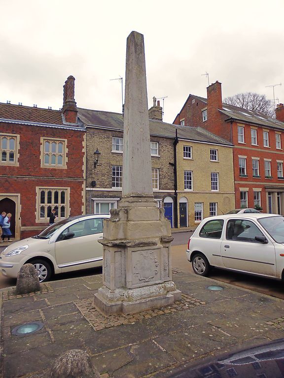
BURY ST EDMUNDS
TL8564SE CHEQUER SQUARE
639-1/8/231 The Obelisk
07/08/52
GV II
Obelisk standing in the centre of Chequer Square. Late C18. A
stone needle on an enriched base.
(BOE: Pevsner N: Radcliffe E: Suffolk: London: 1974-: 150).
Listing NGR: TL8555264051
External links are from the relevant listing authority and, where applicable, Wikidata. Wikidata IDs may be related buildings as well as this specific building. If you want to add or update a link, you will need to do so by editing the Wikidata entry.


Other nearby listed buildings
