Approximate Location Map
Large Map »
Latitude: 52.2435 / 52°14'36"N
Longitude: 0.7148 / 0°42'53"E
OS Eastings: 585445
OS Northings: 264061
OS Grid: TL854640
Mapcode National: GBR QF0.7K5
Mapcode Global: VHKD4.BWR0
Plus Code: 9F426PV7+9W
Entry Name: 25 and 26, Churchgate Street
Listing Date: 20 April 1971
Grade: II
Source: Historic England
Source ID: 1248118
English Heritage Legacy ID: 466707
ID on this website: 101248118
Location: Bury St Edmunds, West Suffolk, IP33
County: Suffolk
District: West Suffolk
Civil Parish: Bury St Edmunds
Built-Up Area: Bury St Edmunds
Traditional County: Suffolk
Lieutenancy Area (Ceremonial County): Suffolk
Church of England Parish: Bury St Edmunds St Mary
Church of England Diocese: St.Edmundsbury and Ipswich
Tagged with: Building
BURY ST EDMUNDS
TL8564SW CHURCHGATE STREET
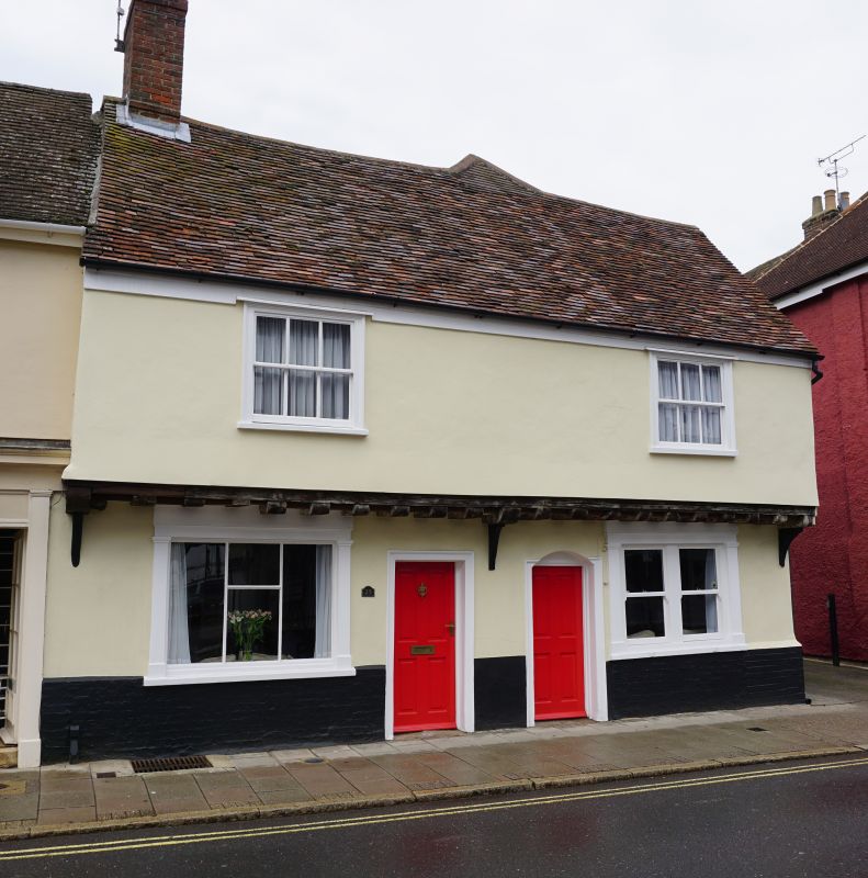
639-1/14/240 (North side)
20/04/71 Nos.25 AND 26
GV II
Shop, formerly divided into 2. Early C16. Timber-framed and
rendered with a high brick plinth and continuous jetty.
Plaintiled roof with a plain eaves soffit.
EXTERIOR: 2 storeys: a 2-bay front range and a short rear
range at right-angles to it. In the east gable wall a beam set
higher than the jetty level indicates a former carriage
entrance into a rear yard. The jetty has been widened to allow
for the insertion of sash windows on the upper storey. 2
window range: 6-paned sashes in heavy cased frames which
project slightly from the wall-surface. 2 C19 shop windows to
the ground storey, each with pilasters and a moulded cornice
to the fascia: on the left, slender glazing-bars, on the right
a single dividing mullion. 2 adjacent 4-panelled doors (one
blocked) in plain architraves.
INTERIOR: exposed timber ceilings to the ground storey. The
2-bay front range has the remains of a C19 chimney-stack set
internally on the west gable wall, but it was formerly
unheated, and divided into 2 shops by a stud partition, now
removed. The rear range, roofed by a single span, was also
divided originally, with a chimney-stack with 2 back-to-back
hearths between the 2 rooms.
In the back wall of the front range, immediately to the left
of the former partition, are the remains of a doorway with a
plain 4-centred arched head which gave access to the western
room of the rear range. This still has an open fireplace,
plastered, with a plain timber lintel. The ceiling-beams and
joists throughout the ground storey are plain, the joists
unchamfered. 3 blocked original stair-traps, one in the
eastern front bay and one in each of the rear rooms, indicate
an irregular division of the premises when first built, with
each dwelling having a shop in the front and a rear
living-room, but the eastern half with access to the major
part of the upper storey. Wide substantial studding and
tension bracing; housings in the wallplates for
diamond-mullioned windows. Upper ceilings a later insertion;
roofs inaccessible.
Listing NGR: TL8544564061
External links are from the relevant listing authority and, where applicable, Wikidata. Wikidata IDs may be related buildings as well as this specific building. If you want to add or update a link, you will need to do so by editing the Wikidata entry.


Other nearby listed buildings
