Approximate Location Map
Large Map »
Latitude: 51.2418 / 51°14'30"N
Longitude: 0.5158 / 0°30'56"E
OS Eastings: 575704
OS Northings: 152187
OS Grid: TQ757521
Mapcode National: GBR PRL.571
Mapcode Global: VHJML.W1KV
Plus Code: 9F326GR8+P8
Entry Name: The Dairy House
Listing Date: 26 February 1987
Grade: II
Source: Historic England
Source ID: 1250499
English Heritage Legacy ID: 432885
ID on this website: 101250499
Location: Loose, Maidstone, Kent, ME15
County: Kent
District: Maidstone
Civil Parish: Loose
Built-Up Area: Maidstone
Traditional County: Kent
Lieutenancy Area (Ceremonial County): Kent
Tagged with: House
KIRKDALE
TQ 7552 LOOSE
(West Side)
6/185
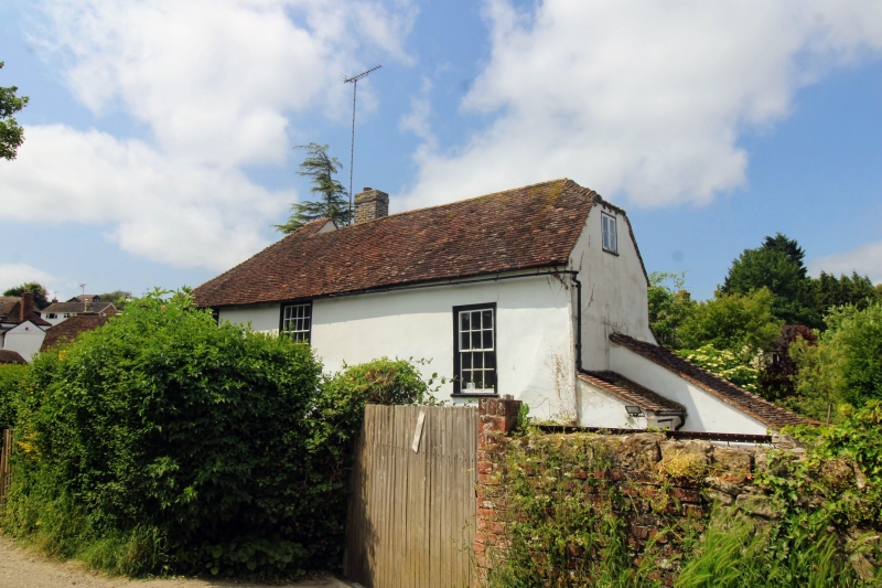
The Dairy House
GV II
House, forge in early C19, beerhouse from 1850's, dairy 1920-55,
now house. C16 or C17 with C18 alterations and early-to-mid C19
additions and facade. Timber-framed, clad with channelled render.
Left gable end weatherboarded. Plain tile roof. One timber-framed
bay of C16 or C17, with second, probably added in C18, to left.
Early-to-mid C19 addition to left end, framed as short cross-wing.
2 storeys and garret. Brick plinth to left of door, stone plinth
to right. Roof broadly hipped to left, with high ridge over left end
bay. Main range half-hipped to right. Rear buff brick stack towards
left end. Irregular fenestration of 3 sashes; one 16-pane sash to
left bay, one to central bay, and one 12-pane sash set much lower
towards right end, under former wall-plate. Boarded door to right of
centre under plain-tile canopy. Rendered rear lean-to. Interior:
chamfered cross-beam to right bay. C18 staircase between walls
opposite front door, with ramped recessed panelling to left wall.
Corner fireplace to central room. Marked on O.S. map as Almery
Cottage.
Listing NGR: TQ7570452187
External links are from the relevant listing authority and, where applicable, Wikidata. Wikidata IDs may be related buildings as well as this specific building. If you want to add or update a link, you will need to do so by editing the Wikidata entry.


Other nearby listed buildings
