Latitude: 51.0648 / 51°3'53"N
Longitude: -1.7996 / 1°47'58"W
OS Eastings: 414139
OS Northings: 129510
OS Grid: SU141295
Mapcode National: GBR 51F.1V6
Mapcode Global: FRA 7639.QQ5
Plus Code: 9C3W3672+W5
Entry Name: College of Sarum St Michael
Listing Date: 28 February 1952
Grade: II
Source: Historic England
Source ID: 1254423
English Heritage Legacy ID: 319053
ID on this website: 101254423
Location: The Close, Wiltshire, SP1
County: Wiltshire
Civil Parish: Salisbury
Built-Up Area: Salisbury
Traditional County: Wiltshire
Lieutenancy Area (Ceremonial County): Wiltshire
Tagged with: College
THE CLOSE
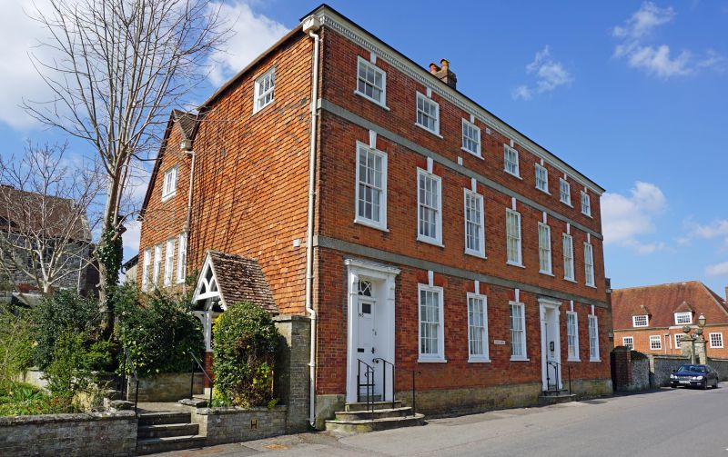
1.
1594
Nos 6] & 64
(College of Sarum St Michael)
SU 1429 NW 3/9 28.2.52.
II GV
2.
Late C18 pair of houses. 3 storey. Red brick on projecting plinth, with
painted strings over ground floor and 1st floor windows, tassled eaves cornice
and hipped old tile roof. 7 windows to upper floors. 5 on ground floor.
All windows have architrave frames and reeded keystones. 2 doorways, one in
left hand corner and one in 3rd bay from right hand. Each door 6-panel with
panel reveal and rectangular fanlight, the left hand curved radiating and
wreathed, the right hand with curved and radiating bar with bead ornament.
Doorcases of pilasters flat console brackets and moulded cornice broken
forward over.
All the listed buildings in the Close form an outstanding group.
Listing NGR: SU1414229510
External links are from the relevant listing authority and, where applicable, Wikidata. Wikidata IDs may be related buildings as well as this specific building. If you want to add or update a link, you will need to do so by editing the Wikidata entry.


Other nearby listed buildings