Latitude: 53.3891 / 53°23'20"N
Longitude: -1.4979 / 1°29'52"W
OS Eastings: 433491
OS Northings: 388144
OS Grid: SK334881
Mapcode National: GBR 99G.BX
Mapcode Global: WHCCJ.Y2WP
Plus Code: 9C5W9GQ2+JR
Entry Name: St Vincents Presbytery
Listing Date: 28 June 1973
Last Amended: 12 December 1995
Grade: II
Source: Historic England
Source ID: 1255156
English Heritage Legacy ID: 458825
Also known as: Sheffield Buddhist Centre
ID on this website: 101255156
Location: Birkendale, Sheffield, South Yorkshire, S6
County: Sheffield
Electoral Ward/Division: Walkley
Parish: Non Civil Parish
Built-Up Area: Sheffield
Traditional County: Yorkshire
Lieutenancy Area (Ceremonial County): South Yorkshire
Church of England Parish: Walkley St Mary
Church of England Diocese: Sheffield
Tagged with: Architectural structure Clergy house
SHEFFIELD
SK38NW HOWARD ROAD 784-1/5/441 (North West side) 28/06/73 St Vincent's Presbytery (Formerly Listed as: HOWARD ROAD St Joseph's Home (original entrance building))
GV II
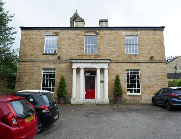
House, now presbytery. Early C19. Coursed squared stone with hipped concrete tile roof and 2 ridge stacks. Plinth, first floor band, rebated eaves. 2 storeys; 3 x 3 windows. Three 12 pane sashes and below, portico with paired Doric columns covering glazed door with overlight. On either side, 20 pane sashes. Left return has two 16 pane sashes and below, a French window and a 20 pane sash. To left, a set back service wing, 2 storeys, 2 windows. INTERIOR not inspected.
Listing NGR: SK3349188143
External links are from the relevant listing authority and, where applicable, Wikidata. Wikidata IDs may be related buildings as well as this specific building. If you want to add or update a link, you will need to do so by editing the Wikidata entry.


Other nearby listed buildings