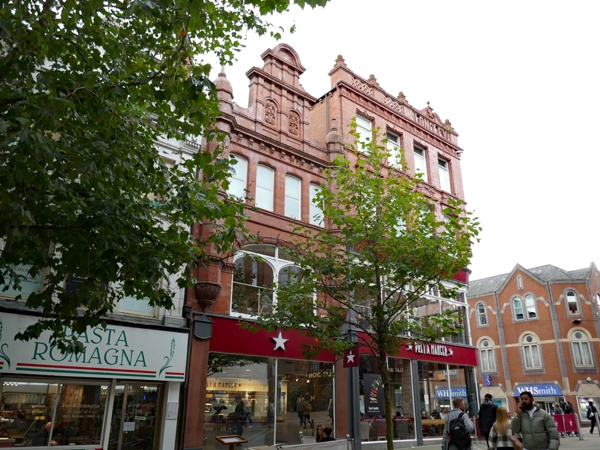
Latitude: 53.7977 / 53°47'51"N
Longitude: -1.5432 / 1°32'35"W
OS Eastings: 430184
OS Northings: 433582
OS Grid: SE301335
Mapcode National: GBR BKL.2F
Mapcode Global: WHC9D.8TC0
Plus Code: 9C5WQFX4+3P
Entry Name: 26, Albion Place
Listing Date: 11 September 1996
Grade: II
Source: Historic England
Source ID: 1256631
English Heritage Legacy ID: 464707
ID on this website: 101256631
Location: Leeds, West Yorkshire, LS1
County: Leeds
Electoral Ward/Division: City and Hunslet
Parish: Non Civil Parish
Built-Up Area: Leeds
Traditional County: Yorkshire
Lieutenancy Area (Ceremonial County): West Yorkshire
Church of England Parish: Leeds City
Church of England Diocese: Leeds
Tagged with: Building
LEEDS
SE3033NW ALBION PLACE 714-1/76/9 (South side) No.26
GV II
Shop premises. Early C20, altered late C20. Terracotta, roof not visible. 3 storeys, 1 bay. Late C20 shop facade ground floor. 1st floor: large showroom window of 2 lights, segmental arch with moulded voussoirs; 4 sashes to 2nd floor, moulded sill band, bracketed eaves cornice, deep pilasters rising from ornate moulded bases at 1st-floor level terminate in small domes with knobbed finials above the parapet and flank the elaborate central panel with flower motifs in arched panels. INTERIOR: not inspected. Possibly the original entrance to Joseph Langley's premises, No.6 Lands Lane (qv), but separately numbered. The style very similar to Nos 50, 52 & 68-74 Vicars Lane (qqv).
Listing NGR: SE3018433582
External links are from the relevant listing authority and, where applicable, Wikidata. Wikidata IDs may be related buildings as well as this specific building. If you want to add or update a link, you will need to do so by editing the Wikidata entry.


Other nearby listed buildings