Approximate Location Map
Large Map »
Latitude: 51.1816 / 51°10'53"N
Longitude: 0.0753 / 0°4'31"E
OS Eastings: 545148
OS Northings: 144532
OS Grid: TQ451445
Mapcode National: GBR LMM.V5L
Mapcode Global: VHHQ3.8K5K
Plus Code: 9F3253JG+J4
Entry Name: Brookside
Listing Date: 16 January 1975
Grade: II
Source: Historic England
Source ID: 1258235
English Heritage Legacy ID: 357223
ID on this website: 101258235
Location: Sevenoaks, Kent, TN8
County: Kent
District: Sevenoaks
Civil Parish: Edenbridge
Traditional County: Kent
Lieutenancy Area (Ceremonial County): Kent
Church of England Parish: Edenbridge St Peter and St Paul
Church of England Diocese: Rochester
Tagged with: Building Thatched building
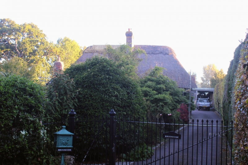
EDENBRIDGE STANFORD'S END
1.
5280
Hartfield Road
Brookside
TQ 44 SE 53/398
II
2.
C16 or earlier timber-framed building of 2 storeys, 3 windows, irregular. High
pitched thatched roof with centre brick stack. Plastered lst floor, painted
brick ground floor. Visible timber framing at back and side. Lattice windows.
Plank door in stout frame in projecting porch.
Listing NGR: TQ4514844532
External links are from the relevant listing authority and, where applicable, Wikidata. Wikidata IDs may be related buildings as well as this specific building. If you want to add or update a link, you will need to do so by editing the Wikidata entry.


Other nearby listed buildings
