Approximate Location Map
Large Map »
Latitude: 52.2531 / 52°15'11"N
Longitude: 0.7145 / 0°42'52"E
OS Eastings: 585385
OS Northings: 265127
OS Grid: TL853651
Mapcode National: GBR QDT.MH0
Mapcode Global: VHKD4.BMLN
Plus Code: 9F427P37+6R
Entry Name: The Linden Tree Public House
Listing Date: 12 July 1972
Last Amended: 30 October 1997
Grade: II
Source: Historic England
Source ID: 1270971
English Heritage Legacy ID: 467044
ID on this website: 101270971
Location: Bury St Edmunds, West Suffolk, IP32
County: Suffolk
District: West Suffolk
Civil Parish: Bury St Edmunds
Built-Up Area: Bury St Edmunds
Traditional County: Suffolk
Lieutenancy Area (Ceremonial County): Suffolk
Church of England Parish: Bury St Edmunds St John the Evangelist
Church of England Diocese: St.Edmundsbury and Ipswich
Tagged with: Pub
BURY ST EDMUNDS
TL8565SW OUT NORTHGATE
639-1/1/509 (West side)
12/07/72 No.7
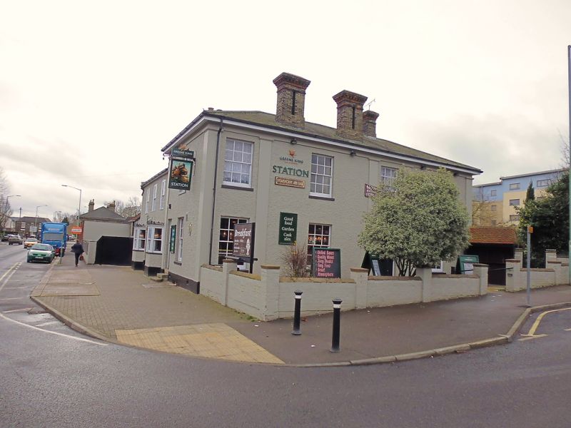
The Linden Tree Public House
(Formerly Listed as:
OUT NORTHGATE
(West side)
No.7
Railway Hotel)
GV II
Public house, built as The Railway Hotel. Mid C19. White
brick, now covered in painted roughcast on the north and east
sides. Hipped slate roof. Corner site.
EXTERIOR: 2 storeys and cellars. Shallow stone pilasters at
the corners, and spaced along the main (north) front, have a
linking frieze below the plain wooden eaves soffit. 4 window
range on north: 12-pane sashes in plain reveals. A C20
entrance door and open porch.
The return front on the east has a single 12-pane sash window;
a 2-storey roughcasted wing has three 12-pane sash windows in
flush cased frames to the upper storey and 2 canted bays to
the ground storey with ornamental cast-iron rails above the
cornices. The windows are large-paned sashes. 2 white brick
chimney-stacks with paired shafts and corbelled heads rise
from just above the eaves on the north side.
An internal white brick stack has red brick details. The south
gable wall of the wing is in flint with 2 external red brick
stacks and red brick quoins.
Listing NGR: TL8538565127
External links are from the relevant listing authority and, where applicable, Wikidata. Wikidata IDs may be related buildings as well as this specific building. If you want to add or update a link, you will need to do so by editing the Wikidata entry.


Other nearby listed buildings
