Latitude: 52.9208 / 52°55'15"N
Longitude: -1.4118 / 1°24'42"W
OS Eastings: 439646
OS Northings: 336097
OS Grid: SK396360
Mapcode National: GBR 6DY.XKC
Mapcode Global: WHDGV.8VZ6
Plus Code: 9C4WWHCQ+87
Entry Name: Pair of Gateways Leading to Spondon School (Upper House) and Adult Centre
Listing Date: 10 November 1967
Last Amended: 24 February 1977
Grade: II*
Source: Historic England
Source ID: 1279402
English Heritage Legacy ID: 403480
ID on this website: 101279402
Location: Spondon, Derby, Derbyshire, DE21
County: City of Derby
Electoral Ward/Division: Spondon
Parish: Non Civil Parish
Built-Up Area: Derby
Traditional County: Derbyshire
Lieutenancy Area (Ceremonial County): Derbyshire
Church of England Parish: Spondon St Werburgh
Church of England Diocese: Derby
Tagged with: Gatepost
1.
5170
SK 33 NE
9/220
10.11.67
PARK ROAD
(South Side)
Spondon
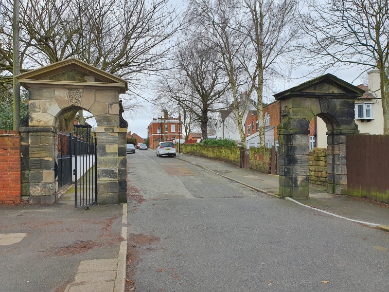
Pair of gateways leading to Spondon School (Upper House) and Adult Centre
(Formerly listed as a pair of gateways formerly leading to Field House in the Rural District of South East Derbyshire
II*
2.
C18. A pair of ashlar gateways With round headed arches, rusticated walling, archivolts;
upright consoles on small attached pilasters at sides; vermiculated keyblocks to
each and cornice and pediment. Gateway on north side retains simple wrought iron
gate. Field House itself has been demolished.
Listing NGR: SK3964636097
External links are from the relevant listing authority and, where applicable, Wikidata. Wikidata IDs may be related buildings as well as this specific building. If you want to add or update a link, you will need to do so by editing the Wikidata entry.


Other nearby listed buildings