Approximate Location Map
Large Map »
Latitude: 51.6671 / 51°40'1"N
Longitude: 0.3842 / 0°23'3"E
OS Eastings: 564981
OS Northings: 199170
OS Grid: TQ649991
Mapcode National: GBR NJW.FYW
Mapcode Global: VHJKD.MC0C
Plus Code: 9F32M98M+RM
Entry Name: Ingatestone Railway Station
Listing Date: 20 February 1976
Last Amended: 9 December 1994
Grade: II
Source: Historic England
Source ID: 1279577
English Heritage Legacy ID: 373698
Also known as: Ingatestone Station
INT
ID on this website: 101279577
Location: Ingatestone, Brentwood, Essex, CM4
County: Essex
District: Brentwood
Civil Parish: Ingatestone and Fryerning
Built-Up Area: Ingatestone
Traditional County: Essex
Lieutenancy Area (Ceremonial County): Essex
Church of England Parish: Ingatestone St Edmund and St Mary
Church of England Diocese: Chelmsford
Tagged with: Railway station
INGATESTONE AND FRYERNING
TQ6499 STATION LANE, Ingatestone
723-1/14/413 (North East side)
20/02/76 Ingatestone Railway Station
(Formerly Listed as:
BRENTWOOD
STATION LANE, Ingatestone
Railway Station}
II
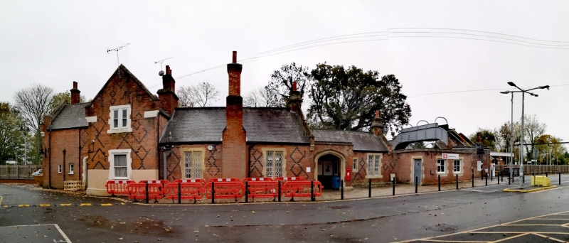
Railway station. 1846. For Eastern Counties Railway. Red brick
English bond with black bricks in diaper patterns, and
limestone dressings roofed with slate. Tudor Revival style.
Arranged along the NW side of the railway line, entrance
elevation to NW: (1) main range of one storey with external
stack to front middle, and smaller stack in right gable end,
(2) entrance porch to right, and lower single-storey block to
rear with stack in right gable end, (3) 2-storey cross-wing
with internal stack at the junction, (4) 2-storey range to
left, most of which is a later rebuild or extension, with 2
stacks in the left end.
All the main windows have chamfered stone surrounds. In the
main range are 2 windows of 2 lights with cast-iron tracery in
hexagon and diamond pattern. The cross-wing has on the ground
floor a late C19 sash of 2 lights, with a severed mullion
indicating that originally it was a pair of narrow sashes, and
on the first floor a pair of sashes of 2 lights, less altered
but not original. The left extension has on the ground floor
one small casement of 2 lights with a segmental brick arch,
and one small C20 casement. The entrance porch has stone jambs
and 4-centred arch chamfered in 2 orders, and a moulded label.
Inside and to left is the main entrance with chamfered stone
jambs and 4-centred arch, boarded door and scrolled
wrought-iron hinges. The diaper pattern covers all the
brickwork except the external stack, which has shoulders of
black brick. In the gable of the cross-wing the date 1846 is
picked out in black bricks. Stone copings and moulded
kneelers. The cross-wing is rendered to a height of O.70m.
Perforated ridge tiles on main range. To left of the
cross-wing is a 4-panel door, the upper panels glazed, with
plain fanlight and chamfered stone dressings and 4-centred
arch. Immediately to left of it the black diaper pattern
ceases, and red bricks of different quality are bonded in.
The left gable end has on the first floor a sash of 2 lights,
and a sash similar to that in the cross-wing, of different
heights, probably re-set. Similar copings and kneelers,
incomplete diaper pattern at top rear of gable. The SE
elevation (towards the platform) has in the main range a
window of 3 lights with original cast-iron tracery in the
middle fixed light, and 2 replaced wooden casements, with
chamfered stone surround; and a fixed light with chamfered
stone jambs and 4-centred arch and cast-iron tracery in
hexagons and diamonds. Beyond the cross-wing is a C20 casement
in original stone surround. Renovation in progress at time of
inspection, May 1989.
Listing NGR: TQ6498199170
External links are from the relevant listing authority and, where applicable, Wikidata. Wikidata IDs may be related buildings as well as this specific building. If you want to add or update a link, you will need to do so by editing the Wikidata entry.


Other nearby listed buildings
